Early British Aviation at Stonehenge.

7 11 2020

Eagle-eyed visitors to Stonehenge’s impressive visitor centre will spot the poignant memorial, which is a reminder of the site’s long association with the military, in particular its aviation wing.

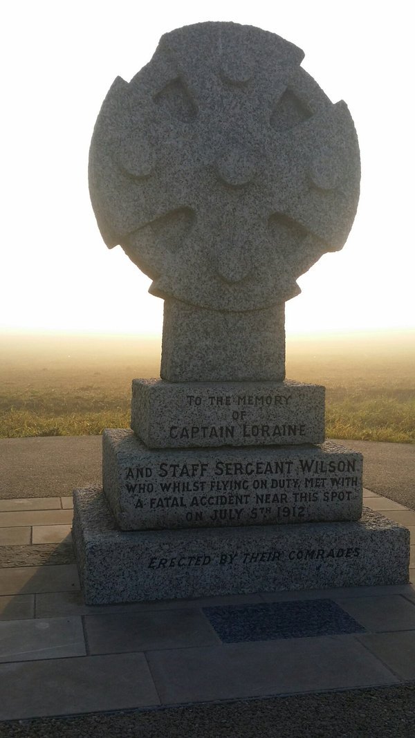
The memorial commemorates the site of an early military aviation accident on 5th July 1912, in which Capt Eustace Loraine and his passenger Staff Sgt Richard Wilson became the first members of the newly formed Royal Flying Corps to die while on duty. The memorial stone was moved in 2012 from Airman’s Corner to make way for a roundabout, as part of the access for the new visitor centre.

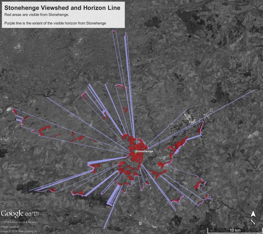
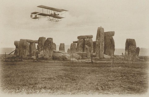
The area’s connection with aviation took off in the 1880s, when reconnaissance balloons belonging to the Royal Engineers could have been seen ascending over the ancient landscape, alarming locals and livestock. From 1897 the War Office started buying up large tracts of land around Stonehenge. They had been using Salisbury Plain for some time for training exercises. The relatively level area around the stones and its remoteness were just what they needed. The Royal Engineer aeronauts bagged the first drone-style aerial photograph of the famous monument in 1906. Three years later aeroplanes arrived on the plain when the wonderfully-named Horatio Barber, a pioneer aviator, rented a strip of land at Durrington Down (now known as Larkhill) and made test flights. The following year military hangars were constructed there. When the British government realised the military application of aeroplanes the Royal Flying Corps was formed. The air arm of the British Army went on to become the Royal Air Force. In its early days flimsy low-powered biplanes (with a maximum speed of 70 mph) were used for observation, with the co-pilot hanging precariously over the side of the cockpit to take photographs – a hazardous occupation, especially with bullets flying! Casualties and fatalities were high – but 80% were caused by mechanical failure and pilot error. One observer who survived, was the remarkable OGS Crawford, who went on to photograph much of Britain from the air after the First World War – and in doing so revealing many hitherto hidden prehistoric monuments and medieval ‘ghost villages’ hidden beneath the crops except from the air when the conditions were right.  It was Crawford, employed by the Ordnance Survey, who in his aerial surveys, revealed the extent of the Stonehenge Avenue. He worked with fellow archaeologist and marmalade heir Alexander Keiller to conduct an aerial survey of many counties in southern England. Together they raised the finances to secure the land around Stonehenge for The National Trust.

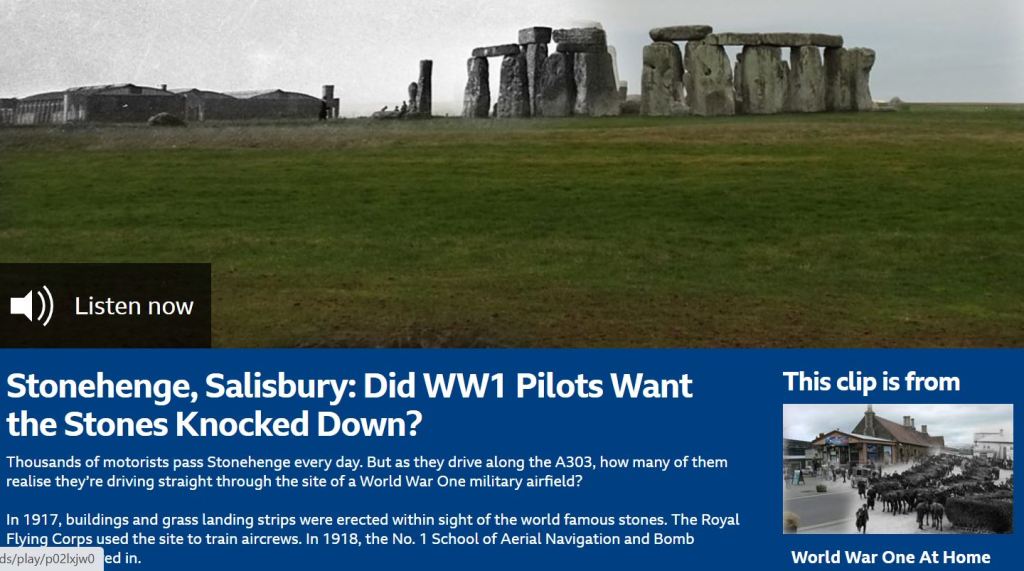
After the devastating bombing raid of summer 1917 by Germany on mainland Britain, when 162 people were killed in a daylight raid in London, the government increased the production of planes, with an especial emphasis on bombers – as war took to the air in a full-blooded way. More airfields were needed for this increased fleet, and Stonehenge was developed as a major aerodrome – in 1917 a 360-acre site was constructed, straddling either side of the A303: one side was the Main (or Day) Camp, the other the Night Camp – the latter was ostensibly for nocturnal missions, but soon both were used, as activity increased. The former RFC training site became the No. 1 School of Aerial Navigation and Bomb Dropping. Handley Page bombers were soon seen rumbling off the airstrip from early 1918 as Britain’s bombing campaign began in earnest. Preparing pilots and spotters for the Western Front, training was intensive and demanding. One of the notorious challenges was known by the airmen as ‘Head in Bag’, which was designed to test a pilot’s ability to fly in a straight line while having their head covered by the observer.

After the Armistice, operations at the Stonehenge aerodrome were slowly wound down, and by 1921 had all but ceased, as concerns for the preservation of the monument and its landscape grew. In 1927 the Stonehenge Protection Committee was set up, and by the early 1930s the aerodrome’s buildings had all been dismantled and removed. And so, military aviation at Stonehenge ceased, except for the occasional fly-by.

So, any who visit Stonehenge, especially around the time of Remembrance Sunday, should pause and spend a moment reflecting on the lives of the brave airmen and personnel who endured hardship, tragedy, and death to keep our skies and coastline safe.

GUEST BLOGGER: Dr Kevan Manwaring is an author, lecturer, and specialist tour-guide. His books include The Long Woman (a novel which features Stonehenge and Avebury) He is a keen walker and loves exploring the ancient landscape of Wiltshire, where he lives with his archaeologist partner

Stonehenge Aviation Links:
First World War Stonehenge Aerodrome | ENGLISH HERITAGE
Stonehenge and Salisbury Military Itinerary – VISIT WILTSHIRE
Stonehenge: Did WW1 Pilots Want the Stones Knocked Down? – BBC
Airman’s Cross | The Accident – THE SARSEN
World War One – The Battle for the Skies – HISTORIC UK
Stonehenge And Salisbury Plain Military History Tour – STONEHENGE TOURS
How Stonehenge site became the world’s largest military training camp – BBC NEWS
Military Commemoration in the Stonehenge Landscape – ARCHAEO DEATH
The Rifles Berkshire and Wiltshire Museum – SALISBURY MUSEUM
Early military ballooning – RAF MUSEUM
Royal Flying Corps – NATIONAL ARMY MUSEUM
The Army Flying Museum. The Museum holds an extensive collection charting over 100 years of the British Army in the air – MUSEUM
Stonehenge from the Air. Fly over historic Stonehenge and look down upon four thousand years of history from the open cockpit of your Tiger Moth – GoFlyUK
Visit Stonehenge with a specialist guide – STONEHENGE GUIDED TOURS
WWI practice tunnels found under Salisbury Plain – BBC

The Stonehenge News Blog
Follow us on Twitter and Facebook for all the latest Stonehenge News
http://www.Stonehenge.News


Stonehenge builders may have transported megaliths down ‘stone highway’ from Wales. Has the secret of Stonehenge been solved?

29 06 2018

The mystery of how the gigantic rocks of Stonehenge were transported may finally have been solved.

A new study claims the huge hunks of hardened earth and minerals were moved from Welsh quarries on a ‘stone highway’ encompassing roads and rivers.

Experts have long been baffled by how the massive boulders were transported from Wales to Salisbury Plain.

Now, they believe they may have found the source for the stones as well as the route used to deliver them from Pembrokeshire to Wiltshire.

  • New study claims to have uncovered the mystery of how Stonehenge was built
  • Giant stones that made up the monolith were transported from Wales to England
  • Experts are baffled as to how neolithic man moved them to Salisbury Plain 
  • New study claims ‘stone highways’ of roads and rivers were used

Stonehenge

Stonehenge, located near Amesbury, in Wiltshire, is an iconic site but historians often debate the origins of its construction and how the stones reached there

The smaller bluestones come from Pembrokeshire, and the huge sarsens come from Marlborough Downs.

However it is unknown where the sandstone of the main Altar Stone originates, but Richard Bevins of the Museum of Wales and Rob Ixer of the University of Leicester told The Times that it “very probably” came from the Senni Beds which go from Llanelli to Herefordshire.

Stonehenge was built in three stages, with some parts being a huge 5,000 years old. The outer bank of Stonehenge was made in around 3000 BC, while the stone settings were built in 2500 BC.

Read the full story:
http://www.dailymail.co.uk/sciencetech/article-5899227/Has-secret-Stonehenge-solved.html
https://www.thesun.co.uk/news/6654449/stonehenge-builders-megaliths-stone-highway-wales/

The Stonehenge News Blog
Follow us on Twitter and Facebook for all the latest Stonehenge News
http://www.Stonehenge.News


Some of the Stonehenge rocks were at Salisbury Plain ‘long before humans’

14 04 2018

Some of the largest rocks at Stonehenge were there long before humans and are not likely to have been moved to the location, an archaeologist says.#


Archaeologists and antiquarians have for centuries wondered why Stonehenge is where it is and why the largest stones were dragged miles to a hillside on Salisbury Plain.

An archaeologist who has excavated within the site says there is evidence people were drawn there because of the stones.

An archaeologist who has excavated within the site says there is evidence people were drawn there because of the stones.

It had been thought those stones, called sarsens, were brought from the Marlborough Downs, 20 miles (32km) away.

Mike Pitts, one of only a few archaeologists to have excavated within Stonehenge, has found evidence that two of the largest sarsen stones have been there for millions of years.

The largest megalith at the site, the heel stone, which aligns with sunrise on midsummer’s day, is 75 metres from the centre of the stone circle and weighs 60 tonnes.

Read the full (source) story here

The Stonehenge News Blog
Follow us on Twitter and Facebook for all the latest Stonehenge News
http://www.Stonehenge.News


Other Sarsen Stones near Stonehenge and Woodhenge

5 02 2017

Sarsen boulders lie scattered in substantial “drifts” across the landscape of the Marlborough Downs near Avebury.

By contrast, close to Stonehenge there are almost none. This is one of the reasons why most archaeologists believe that the large sarsens for the monument were not locally sourced.

There are, however, a few examples of substantial sarsens dotted about Salisbury Plain within a couple of miles of Stonehenge. And there are tantalising hints that others used to exist.

The most obvious, and easily accessible, is the Cuckoo Stone. This stone is about 2m long by 1.5m wide by 1.5m thick and lies in the field immediately west of Woodhenge.

Cuckoo Stone

The Stonehenge Riverside Project excavated around the Cuckoo Stone in 2007 and discovered that the stone once had been set upright right next to the hollow in which it had originally formed.

Close by were two neolithic pits containing pottery worked flint, deer antlers and animal bones, dating to between 4000BC and 2000BC. A series of three burials were also found close by, dating to around 2000BC.

The stone remained a focus of activity right down to Romano-British times, and a small square wooden building – most likely a shrine – was built immediately to its southwest. Coins and pottery found in the ploughsoil date this to between 200AD and 400AD.

The other readily accessible sarsen is the Bulford Stone which lies in an arable field east of Bulford Village. It’s rather larger than the Cuckoo Stone at 2.8m long and again the excavation evidence shows that it too was once stood upright next to the hollow in which it formed.

It’s also closely associated with burials from the neolithic, the pottery found here dates to between 2300BC and 1900BC. The grave goods found were remarkable, including a flake of transparent rock crystal from either South Wales or the Alps and a “mini megalith” carved from a piece of limestone.

Bulford Stone.jpg

Lying in the northern ditch of a badly degraded long barrow within the Salisbury Plain military training area (and therefore not accessible to the public) are three more sarsen boulders.

They vary in size and – being half buried in the turf – are difficult to see, but the largest seems to be almost 2m long.

This long barrow was excavated by John Thurnam in 1864 who found an early neolithic burial on the original ground surface and an later Beaker burial just below the top of the mound.

Subsequent digging by the military in the early 20th century has almost obliterated the barrow but its outline can still be made out.

There is some debate about whether the sarsens lying in the ditch were originally part of the structure of the long barrow or if they were dragged there by farmers clearing fields at some later date. The stronger possibility is that they were part of the structure.

long-barrow-sarsens

John Britton in his “Beauties of Wiltshire (1801)” says:

“About two miles north of Amesbury, on the banks of the Avon, is Bulford. Near this village are two large stones of the same kind as those at Stonehenge. One of them is situated in the middle of the river, and, as I am informed, has an iron ring fixed in it; but the waters being very high I could not see it.”

Old OS maps of the area show where this stone in the river once lay, but sadly it has now been removed and its present location is unknown to this author (please get in touch if you have any information about or pictures of it):
location-of-sarsen-in-river-os
“…
an interment which was lately discovered above Durrington Walls, by a shepherd, who in pitching the fold, found his iron bar impeded in the ground : curiosity led him to explore the cause, which proved to be a large sarsen stone, covering the interment of a skeleton”

There are other references to large local sarsens from antiquarian reports – one is mentioned by Sir Richard Colt Hoare in the early 1800s:

… and another by the Rev. Allan Hutchins from about the same time:

“In a field, not far from the road which leads from the Amesbury Turnpike into Bulford, is a Barrow of chalk facing the parish and standing by itself… When I came nearly to the virgin earth in this Barrow, my progress was impeded by an immense oval sand stone, underneath which was a skeleton, a beautiful lance head, and a handsome drinking cup”

Perhaps there are still more to be found. Certainly it seems that sarsen boulders of “large” or even “immense” size are not unknown in this part of Wiltshire so maybe the idea that the sarsens of Stonehenge were brought from the Marlborough Downs shouldn’t be accepted at face value.

Here’s a view from Beacon Hill on the east side of Amesbury:

labelled-view-from-beacon-hill

… and here’s an overhead view from Google Earth:

locations-of-sarsens-around-stonehenge

Curiously the Cuckoo Stone, the Avon Sarsen and the Bulford Stone all lie precisely on a straight line, with the Avon Stone being 1500 yards from the Cuckoo Stone and 1450 yards from the Bulford Stone.

But that’s another story……….

Want to learn more and here more Stonehenge stories? Hire a local expert tour guide or join a scheduled group tour
The Stonehenge Travel Company based in nearby Salisbury are considered the local experts and conduct guided tours of the Stonehenge landscape. Stonehenge Guided Tours include photo stops of Durrington Walls and Woodhenge and their private group tours service offer trips from London, Salisbury and Bath.  Stonehenge Walks offer archaeological guided walking tours

Article by guest blogger and local Stonehenge historian Simon Banton

The Stonehenge News Blog
Follow us on Twitter and Facebook for all the latest Stonehenge News
http://www.Stonehenge.News


New discoveries rewrite Stonehenge landscape

29 11 2016

Archaeologists have found new evidence that rewrites the history of the Stonehenge landscape.  One of the newly-discovered sites even predates the construction of the world famous monument itself.

arrow-stones

FASCINATING FINDS: Flint arrow heads give a secure early Neolithic date

The remains, found at Larkhill and Bulford, were unearthed during excavations being carried out before the building of a series of brand new Army houses.

At Larkhill, the discovery of a Neolithic causewayed enclosure – a major ceremonial gathering place some 200 meters in diameter – dating from around 3650 BC radically changes our view of the Stonehenge landscape. About 70 enclosures of this type are known across the UK, although this is only the second discovery in the Stonehenge landscape, with the other further to the northwest at Robin Hood’s Ball on the Salisbury Plain Training Area. In the Wessex region they occur on hilltops and, along with long barrows, are some of the earliest built structures in the British landscape.

FASCINATING FINDS – 700 yrs older than Stonehenge:

The Larkhill enclosure has produced pottery, worked flint, a saddle quern, animal bone and human skull fragments, all placed in the ditches which define the enclosure. Sites of this type were used for temporary settlement, to exchange animals and other goods, for feasting and other ritual activity, including the disposal of the dead. The objects found in the ditches reflect these ceremonial practices. The Larkhill causewayed enclosure is around 700 years older than Stonehenge and is part of a landscape that included other large earth and timber structures such as long barrows and cursus monuments. Its builders shaped the landscape into which the stone circle at Stonehenge was placed, which was already special long before Stonehenge was constructed. The causewayed enclosure at Larkhill shows that they had the social organisation necessary to come together to create significant earthworks, and the resources to support the work, as well as the people to carry it out.

Dr Matt Leivers of Wessex Archaeology told Spire FM

“This is an exciting new find and one that transforms our understanding of this important monumental landscape.”

While part of the site has been investigated, the majority of it lies within the Larkhill Garrison, where it remains unaffected by the current works.

LOOK – PHOTOS: There are more pictures of the finds in the mini gallery below…

UNIQUE DOUBLE HENGE:

At nearby Bulford, archaeologists have found a unique double henge, the only example known in Britain. The earliest phases were created around 2900 BC with circular enclosures formed by ditches dug in segments with openings to the north. In the Early Bronze Age (around 2000 BC) both henges were enclosed within continuous ditches, and perhaps buried beneath barrow mounds. From one of the Bulford henges a skull from a large dog or wolf, perhaps a working companion, a trophy from the hunt, or even a totemic symbol, was recovered.

Martin Brown, Principal Archaeologist for WYG told Spire FM:

“These discoveries are changing the way we think about prehistoric Wiltshire and about the Stonehenge landscape in particular. The Neolithic people whose monuments we are exploring shaped the world we inhabit: They were the first farmers and the first people who settled down in this landscape, setting us on the path to the modern world. It is an enormous privilege to hold their tools and investigate their lives.”

ARMY HOUSING WORKS CONTINUE:

Archaeological work on both sites is being managed and directed by WYG on behalf of Defence Infrastructure Organisation (DIO), with fieldwork undertaken by Wessex Archaeology.

The sites’ development is part of wider plans to accommodate the 4000 additional Service personnel plus their families who will be based on and around Salisbury Plain by 2019 under the Army Basing Programme. In total, the MOD is planning to invest more than £1 billion in the area which will provide more than 900 new homes for Service families, over 2,600 new bed spaces for single soldiers and the construction, conversion or refurbishment of 250 other buildings within bases, such as offices, garages, workshops and Mess facilities.

Find out more about WYG and the work at Bulford and Larkhill here: www.wyg.com

Read the full story (source) on the SPIRE FM website

The Stonehenge News Blog
Follow us on Twitter and Facebook  and for all the latest Stonehenge news and Winter Solstice updates.


Why did the builders of Stonehenge choose Salisbury Plain?

23 10 2016

One of the most frequently asked questions about Stonehenge is “Why is it where it is?” and there are several possible explanations for this. They’re described below but it’s important to understand that combinations of these are also possible – there may not be just one single reason.

The location isn’t at all the obvious choice because it’s not at the top of the slope, which rises further towards the west. However, if you analyse the terrain you realise that it’s ideally positioned to give medium to long distance views to the northeast, southeast, southwest and northwest over a horizon that is relatively flat in profile.

In fact, the horizon is less than 1° in elevation in all directions.

Salisbury Plain

Archaeologists believe that there were only isolated stands of trees in the Salisbury Plain landscape at the time Stonehenge was built, far fewer than are evident today, so the far-reaching views that are hidden today by modern plantations wouldn’t have been obscured.

viewshed-and-horizon

In the Google Earth image the areas coloured red are directly visible from Stonehenge while the purple line shows the extent of the visible horizon (without trees in the way).

So why not build it further up the westerly slope and achieve even further-reaching views? To do so would be to lose some of the flatness of the horizon in key directions. As it is, Stonehenge appears to be in the centre of a bowl of visibility where the directions to the important astronomical events of summer and winter solstice sunrise and sunset are clear and level.

The second theory relates to the Station Stone Rectangle. Originally there were four Station Stones situated just inside the henge bank. Only two remain in place, the positions of the others (whose stoneholes have been detected) are known.

The short sides of this rectangle are parallel to the main alignment at Stonehenge – winter solstice sunset to summer solstice sunrise. In 1966, C.A. “Peter” Newham pointed out in an article in

station-stone-rectangle

Nature that the long sides of the rectangle are aligned on the extreme moonrise and moonset positions, in a cycle that takes 18.6 years to complete.

It’s a feature of the astronomical geometry that only at the latitude of Stonehenge (give or take 30 miles) that these solar and lunar alignments occur at right angles to each other. Further north or south than that limit and the Station Stone Rectangle would become a parallelogram.

The third possibility concerns the Heel Stone and the Avenue. The Heel Stone is an unshaped sarsen boulder weighing in at over 35 tons that is positioned to the northeast of Stonehenge at the top of the ceremonial approach way called the Avenue. It is traditionally associated with marking the position of sunrise on the summer solstice as seen from the centre of the circle.

During excavations by the Stonehenge Riverside Project in the mid-2000s, a series of features were discovered at the top of the Avenue which have been identified as “periglacial stripes”. These cracks and runnels in the underlying chalk where water has repeatedly frozen and thawed happen to run exactly along the main solstice alignment down the slope to the northeast beyond the Heel Stone.

periglacial

The SRP team suggest that these features would have been visible as parallel lines in the grass leading towards the Heel Stone. They go on to suggest that since the Heel Stone is unshaped, it may always have been lying in the landscape very close to where it has been set upright.

They conclude that a series of noticeable stripes in the grass leading up a slope towards a massive rock exactly in the direction of the winter solstice sunset may be the reason why this spot was regarded as a special place, worthy of memorialising.

Fourthly, there’s the theory that the combination of Bluestones from Wales with Sarsens from the more local area represents the symbolic political unification of two different groups of people at this spot on the borderland between their separate spheres of influence.

We do know that the area has been a focus of activity for more than 10,000 years going right back to the end of the last Ice Age in Britain, as shown by the recent discoveries at Blick Mead in Amesbury, and there are the massive Mesolithic post holes in the landscape only a couple of hundred metres northwest of Stonehenge.

Perhaps we’re looking at the continuation of a specialness that was handed down across the generations, with each successive group embellishing the stories and the monumentalisation a little for itself until finally we end up with a Visitor Centre that receives over a million people a year.

Ultimately though, the reasons for the choice of this location will remain one of the more puzzling Stonehenge mysteries.
Article by guest blogger and local Stonehenge historian Simon Banton

Salisbury Plain links:
Salisbury Plain Safaris offers a unique look at the dramatic landscapes, rich history and picturesque villages surrounding Salisbury, Stonehenge and the surrounding villages.
Stonehenge Guided Tours offer unique guided tours of the Stonehenge landscape and Salisbury Plain
Stonehenge ATV. This is what you have been looking for – the ultimate two seater buggy Salisbury Plain experience.
Visit Wiltshire.  Looking for more information on the famous Salisbury plain?…If so, click here to get the latest information direct from the official Wiltshire tourism site!

The Stonehenge News Blog
Follow us on Twitter and Facebook for all the latest Stonehenge news and discoveries


Bronze Age burial near Stonehenge discovered by badger

9 02 2016

A Bronze Age cremation burial has been discovered near Stonehenge after being accidentally dug up by a badger.

bronze-age-find

An archer’s wrist guard and shaft straighteners were among the objects discovered

Objects found in a burial mound at Netheravon, Wiltshire, include a bronze saw, an archer’s wrist guard, a copper chisel and cremated human remains.

Experts believe the burial may have been that of an archer or a person who made archery equipment.

The artefacts date back to 2,200-2,000BC, senior archaeologist Richard Osgood, of the MOD, said.

The burial mound, about five miles north of Stonehenge, lies on MOD land.

Mr Osgood, from the MOD’s Defence Infrastructure Organisation, said it was “an exciting find”.

“It was utterly unexpected. These are wonderful artefacts from the early Bronze Age, about 2,200-2,000 BC,” he said.

wilts-map

Other archaeological finds in Wiltshire:

1. Bronze Age burial discovered by a badger

2. Soldiers uncover 27 ancient bodies at Barrow Clump on Salisbury Plain

3. Researchers find large Neolithic site at Durrington Walls

4. Stonehenge dig finds 6,000-year-old encampment at Blick Mead

5. Bronze Age child’s skeleton discovered at Wilsford henge

6. Bronze Age jewellery discovered in a Wiltshire field

7. Iron Age woman’s footless body found near West Knoyle

8. Bronze Age hoard found near Tisbury


Also among the finds were shaft straighteners for straightening arrows, and pieces of pottery.

Mr Osgood said the badger had dug out the cremation urn and sherds of pottery were lying on the surface when they were spotted.

A full archaeological dig was then carried out on the site.

Mr Osgood said: “There are badger setts in quite a few scheduled monuments – the actions of burrowing animals is one of the biggest risks to archaeology in Britain – but to bring out items of this quality from one hole is unusual.

“We would never have known these objects were in there, so there’s a small part of me that is quite pleased the badger did this… but it probably would have been better that these things had stayed within the monument where they’d resided for 4,000 years.”

Injured military personnel and veterans helped to excavate the site.

The items are due to be put on display at Wiltshire Museum in Devizes later this year.

Read the full story (source) on the BBC website

The Stonehenge News Blog


Stonehenge may have been first erected in Wales, ‘amazing’ finds suggest

7 12 2015

‘Evidence that bluestones were quarried in Wales 500 years before they were put up in Wiltshire prompts theory that Stonehenge is ‘second-hand monument’

Archaeologists at one of the Stonehenge quarry sites in Wales. Photograph: UCL

Archaeologists at one of the Stonehenge quarry sites in Wales. Photograph: UCL

Evidence of quarrying for Stonehenge’s bluestones is among the dramatic discoveries leading archaeologists to theorise that England’s greatest prehistoric monument may have first been erected in Wales.

It has long been known that the bluestones that form Stonehenge’s inner horseshoe came from the Preseli hills in Pembrokeshire, around 140 miles from Salisbury Plain.

Now archaeologists have discovered a series of recesses in the rocky outcrops of Carn Goedog and Craig Rhos-y-felin, to the north of those hills, that match Stonehenge’s bluestones in size and shape. They have also found similar stones that the prehistoric builders extracted but left behind, and “a loading bay” from where the huge stones could be dragged away.

Carbonised hazelnut shells and charcoal from the quarry workers’ campfires have been radiocarbon-dated to reveal when the stones would have been extracted.

Prof Mike Parker Pearson, director of the project and professor of British later prehistory at University College London (UCL), said the finds were “amazing”.

“We have dates of around 3400 BC for Craig Rhos-y-felin and 3200 BC for Carn Goedog, which is intriguing because the bluestones didn’t get put up at Stonehenge until around 2900 BC,” he said. “It could have taken those Neolithic stone-draggers nearly 500 years to get them to Stonehenge, but that’s pretty improbable in my view. It’s more likely that the stones were first used in a local monument, somewhere near the quarries, that was then dismantled and dragged off to Wiltshire.”

The dating evidence suggests that Stonehenge could be older than previously thought, Parker Pearson said. “But we think it’s more likely that they were building their own monument [in Wales], that somewhere near the quarries there is the first Stonehenge and that what we’re seeing at Stonehenge is a second-hand monument.”

There is also the possibility that the stones were taken to Salisbury Plain around 3200 BC and that the giant sarsens – silicified sandstone found within 20 miles of the site – were added much later. “Normally we don’t get to make that many fantastic discoveries in our lives,” Parker Pearson said. “But this is one.”

Parker Pearson heads a project involving specialists from UCL and the universities of Manchester, Bournemouth and Southampton, among others. Their findings are published on Monday in the journal Antiquity alongside a new book by the Council for British Archaeology titled Stonehenge: Making Sense of a Prehistoric Mystery.

Prof Kate Welham, of Bournemouth University, said the ruins of a dismantled monument were likely to lie between the two megalith quarries. “We’ve been conducting geophysical surveys, trial excavations and aerial photographic analysis throughout the area and we think we have the most likely spot. The results are very promising. We may find something big in 2016,” she said.

The long-distance transport of the bluestones from Wales to Stonehenge is one of the most remarkable achievements of Neolithic societies. The archaeologists estimate that each of the 80 monoliths weighed less than two tons and that people or oxen could have dragged them on wooden sledges sliding on rail-like timbers.

Parker Pearson said people in Madagascar and other societies were known to have moved such standing stones long distances and that doing so created a spectacle that brought together communities from afar.

“One of the latest theories is that Stonehenge is a monument of unification, bringing together people from across the many parts of Britain,” he said.

He recalled the moment he looked up the near-vertical rock-face and realised that this was one of the quarries. “Three metres above us were the bases of these monoliths that were actually sitting there ready simply to be lowered out of their recesses,” he said.
“It’s the Ikea of Neolithic monument building. The nice thing about these particular outcrops is that the rock has formed 480 million years ago as pillars. So prehistoric people don’t have to go in there and bash away … All they have to do is get wedges into the cracks. You wet the wedge, it swells and the stone pops off the rock.”

 Article source:  (Guardian News)
The Stonehenge News Blog


LECTURE: Old Stones, New ideas: Sourcing the Stonehenge Bluestones

10 10 2015

A Saturday afternoon lecture by Richard Bevins at the Wiltshire Museum. 21st November 2015

Stonehenge is arguably one of the most famous prehistoric monuments in the World. It is renowned for the Stonehenge Lectureenormous size of the sarsen monoliths used in its construction which comprise the Outer Circle and Outer Horseshoe. It is generally agreed that these stones were sourced from the Marlborough Downs area, some 30 km to the north of Stonehenge. However, a set of smaller stones, comprising the Inner Circle, the Inner Horseshoe and the Altar Stone, are exotic to the Salisbury Plain area; these are the so-called bluestones, and have been the subject of investigations since the latter part of the 19th Century. Early petrographical studies recognised that the bluestones largely comprise a range of altered volcanic, intrusive and tuffaceous rocks with rarer sandstones but could not provide a definitive source.

However, it was the seminal paper by H.H. Thomas in 1923 that persuasively demonstrated that the spotted dolerite component of the bluestones could be sourced to outcrops exposed towards the eastern margin of Mynydd Preseli in southwest Wales, citing the tors Carn Meini and Cerrigmarchogion as the most likely sources. Thomas also argued that other lithologies in the bluestone assemblage, notably the rhyolites and the ‘calcareous ash’, could be sourced in the same locale, in particuar from Carn Alw and the northern slopes of Foel Drygarn respectively.

The first major investigation of the geochemistry of bluestone assemblage was by Richard Thorpe and team who compared whole rock wavelength-dispersive X-ray fluorescence spectrometry analyses from both orthostats and debitage at Stonehenge with whole rock analyses from Mynydd Preseli
.
Using petrography, mineral chemistry and whole rock geochemistry Richard Bevins and Rob Ixer have re-examined the proposed source of the bluestone rhyolites and determined that Carn Alw, as proposed by Thomas, is not the source of bluestone rhyolite; instead they argued that the majority of the rhyolite debitage from the Stonehenge Landscape (but not the four rhyolitic/dacitic standing or recumbent orthostats) comes instead from a prominent outcrop called Craig Rhos y felin, located on low ground to the north of the Mynydd Preseli range in the vicinity of Brynberian. More recently they have re-examined the spotted and non-spotted dolerites and concluded that a large % of the dolerite fragments and cored samples from Stonehenge come from Carn Goedog rather than Carn Meini.

Biography
Dr Richard Bevins as Keeper and Head of the Department of Natural Sciences at the National Museum Wales in Cardiff is responsible for Strategic leadership for collections and research related activities within the Department.

Qualifications, memberships and relevant positions:
BSc (Hons) Geology (Aberystwyth University), PhD (Keele), Fellow (Geological Society of London), Chartered Geologist (CGeol), Fellow (Society of Antiquaries of London), Honorary Lecturer (School of Earth & Ocean Sciences, Cardiff University), Chair, Geological Society of London’s Geoconservation Committee, Member of the Geological Society of London’s External Relations Committee, Chair of the British Geological Survey’s National Geological Repository Advisory Committee.

References
Primary research area is centred on the the Caledonian igneous history of Wales and related areas, as well as on their low-grade metamorphism. More recent work has focussed on extending the petrology and geochemistry of altered igneous rocks from Pembrokeshire into a re-examination of the source of the Stonehenge bluestones.

Links:
http://www.wiltshiremuseum.org.uk/events/index.php?Action=2&thID=1029&prev=1
www.researchgate.net/profile/Richard_Bevins2

Saturday afternoon lectures start at 2.30pm and last approx. one hour.

Our Lecture Hall is accessible via a lift if required, has a hearing loop and air conditioning.
Booking Options
Book online using Paypal
Telephone – 01380 727369
Email – hello@wiltshiremuseum.org.uk

The Stonehenge News Blog


RSPB creates wildflower meadow for butterflies at Stonehenge World Heritage Site.

9 02 2015

Hundreds of wildflowers have been planted at Normanton Down on the Stonehenge World Heritage Site to help gives butterflies a home during the summer months.

Flowers such as classic chalk grassland herbs, common rockrose and wild thyme are among many more that make up the wildflower meadow that was created on four iron-age barrows across the ancient site.

The wildflowers, which were all grown from seed and collected from Salisbury Plain, will serve as a food source for the caterpillars of the iconic chalk downland butterfly and many pollinators during the summer season.

The work for the project was completed by the RSPB, who manage the Normanton Down nature reserve, which is known for its ground nesting birds and downland wildlife.

Stonehenge Flowers

Chalkhill Blue – female © Tony Davison, from the surfbirds galleries.

RSPB Site Manager, Patrick Cashman, said: “These barrows already support fragments of a once more widespread flower-rich downland landscape. We are taking this opportunity to top them up with key butterfly food plants, so their warm southern flanks can become new homes for butterflies from nearby Salisbury Plain and help provide stepping stones in the wider landscape.”

The wildflower planting was funded by the Heritage Lottery Fund as a part of ‘Save Our Magnificent Meadows’ project, which is a national partnership of 11 organisations led by Plantlife to help transform the fortunes of vanishing meadows, grasslands and wildlife.

English Heritage’s Stonehenge World Heritage Site co-ordinator, Beth Thomas, said: “We are delighted to see the historic monument being treasured for their relict ancient grassland, and having their profile raised as resource to help reconnect the natural and historic landscape.”

Through the RSPB’s Giving Nature a Home campaign, you can help tackle the housing crisis facing the UK’s threatened wildlife. The charity is asking people to provide a place for wildlife in their own gardens and outside space – whether it’s a dead wood pile for mini beats and other insects, putting up a nestbox for a house sparrow, or creating a pond that will support a number of different species.

To find out more about Giving Nature a Home and to receive a free guide packed full of simple, fun activities to help wildlife where you live, visit: rspb.org.uk/homes

Notes

1. The RSPB is the UK’s largest nature conservation charity, inspiring everyone to give nature a home. Together with our partners, we protect threatened birds and wildlife so our towns, coast and countryside will teem with life once again. We play a leading role in BirdLife International, a worldwide partnership of nature conservation organisations.

2. Giving Nature a Home is the RSPB’s latest campaign, aimed at tackling the housing crisis facing the UK’s threatened wildlife. The charity is asking people to provide a place for wildlife in their own gardens and outside spaces – whether it by planting pollen-rich plants to attract bees and butterflies, putting up a nestbox for a house sparrow, or creating a pond that will support a number of different species. The charity hopes to inspire people across the UK to create a million new homes for nature.

3. Normanton Down lies within the Stonehenge World Heritage Site, and comprises 47 ha of former arable land in the process of being reverted to species-rich chalk grassland, through a management agreement with the private owner. Reseeding of the arable land has taken place over the last three years, and the diversity of wild flowers, along with butterflies and other invertebrates, is gradually increasing. The site is also being managed to encourage breeding stone-curlews and other birds such as lapwings and corn buntings.

4. The wildflowers that are being planted on the site are; the classic chalk grassland herbs; kidney and horseshoe vetch, common rockrose, wild thyme, dropwort, harebell, small scabious and devil’s-bit scabious.

5. Iconic downland butterflies expected on the site include; chalkhill blue, adonis blue, brown argus and marsh fritillary.

Article source: http://www.surfbirds.com/community-blogs/blog/2015/02/08/rspb-creates-wildflower-meadow-for-butterflies-at-stonehenge/

The National Trust offer guided tours though the Stonehenge Landscape: http://www.nationaltrust.org.uk/stonehenge-landscape/

The Stonehenge News Blog