The origin of the giant sarsen stones at Stonehenge has finally been discovered with the help of a missing piece of the site which was returned after 60 years.

30 07 2020

Last year archaeologists pinpointed the origin of many of the ancient monument’s massive stones. A new study identifies the source of the rest. A test of the metre-long core was matched with a geochemical study of the standing megaliths.

Stonehenge

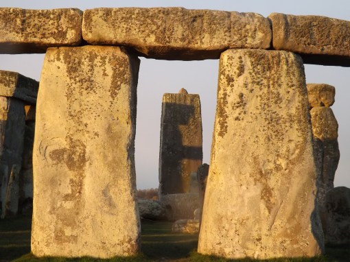
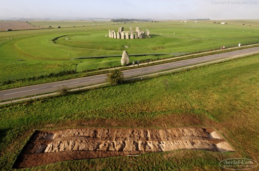
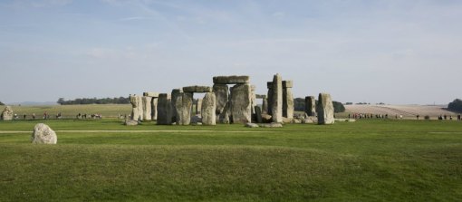
The 23ft sarsens each weigh around 20 tonnes

Archaeologists pinpointed the source of the stones to an area 15 miles (25km) north of the site near Marlborough.

English Heritage’s Susan Greaney said the discovery was “a real thrill”.

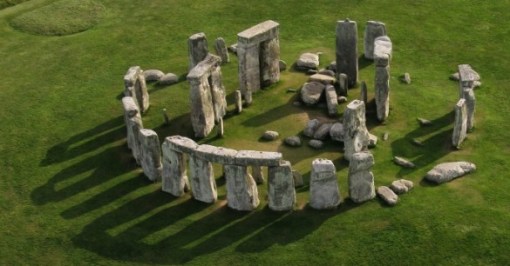
The seven-metre tall sarsens, which weigh about 20 tonnes, form all fifteen stones of Stonehenge’s central horseshoe, the uprights and lintels of the outer circle, as well as outlying stones.

The monument’s smaller bluestones have been traced to the Preseli Hills in Wales, but the sarsens had been impossible to identify until now.

The return of the core, which was removed during archaeological excavations in 1958, enabled archaeologists to analyse its chemical composition.

No-one knew where it was until Robert Phillips, 89, who was involved in those works, decided to return part of it last year.

Researchers first carried out x-ray fluorescence testing of all the remaining sarsens at Stonehenge which revealed most shared a similar chemistry and came from the same area.

They then analysed sarsen outcrops from Norfolk to Devon and compared their chemical composition with the chemistry of a piece of the returned core.

English Heritage said the opportunity to do a destructive test on the core proved “decisive”, as it showed its composition matched the chemistry of sarsens at West Woods, just south of Marlborough.

Prof David Nash from Brighton University, who led the study, said: “It has been really exciting to harness 21st century science to understand the Neolithic past, and finally answer a question that archaeologists have been debating for centuries.

‘Substantial stones’

“Each outcrop was found to have a different geochemical signature, but it was the chance to test the returned core that enabled us to determine the source area for the Stonehenge sarsens.”

Ms Greaney said: “To be able to pinpoint the area that Stonehenge’s builders used to source their materials around 2,500 BC is a real thrill.

“While we had our suspicions that Stonehenge’s sarsens came from the Marlborough Downs, we didn’t know for sure, and with areas of sarsens across Wiltshire, the stones could have come from anywhere.

“They wanted the biggest, most substantial stones they could find and it made sense to get them from as nearby as possible.”

Ms Greaney added the evidence highlights “just how carefully considered and deliberate the building of this phase of Stonehenge was”.
SOURCE: BBC NEWS

STONEHENGE RELEVANT NEWS:

Stonehenge: Mystery of mighty stones solved by archaeologists – THE INDEPENDENT
Origin of Stonehenge’s huge standing stones discovered after part of monument found in US – ITV NEWS
Mystery of origin of Stonehenge megaliths solved – BBC NEWS
Mystery of where Stonehenge’s giant stones come from solved – SKY NEWS
Whence Came Stonehenge’s Stones? Now We Know – NYC TIMES
Visit Stonehenge and hear all the latest theories – STONEHENGE GUIDED TOURS
Origin of Stonehenge’s huge standing stones discovered after part of monument found in US – ITV NEWS

The Stonehenge News Blog
Follow us on Twitter and Facebook for all the latest Stonehenge News
http://www.Stonehenge.News


Why did the builders of Stonehenge choose Salisbury Plain?

23 10 2016

One of the most frequently asked questions about Stonehenge is “Why is it where it is?” and there are several possible explanations for this. They’re described below but it’s important to understand that combinations of these are also possible – there may not be just one single reason.

The location isn’t at all the obvious choice because it’s not at the top of the slope, which rises further towards the west. However, if you analyse the terrain you realise that it’s ideally positioned to give medium to long distance views to the northeast, southeast, southwest and northwest over a horizon that is relatively flat in profile.

In fact, the horizon is less than 1° in elevation in all directions.

Salisbury Plain

Archaeologists believe that there were only isolated stands of trees in the Salisbury Plain landscape at the time Stonehenge was built, far fewer than are evident today, so the far-reaching views that are hidden today by modern plantations wouldn’t have been obscured.

viewshed-and-horizon

In the Google Earth image the areas coloured red are directly visible from Stonehenge while the purple line shows the extent of the visible horizon (without trees in the way).

So why not build it further up the westerly slope and achieve even further-reaching views? To do so would be to lose some of the flatness of the horizon in key directions. As it is, Stonehenge appears to be in the centre of a bowl of visibility where the directions to the important astronomical events of summer and winter solstice sunrise and sunset are clear and level.

The second theory relates to the Station Stone Rectangle. Originally there were four Station Stones situated just inside the henge bank. Only two remain in place, the positions of the others (whose stoneholes have been detected) are known.

The short sides of this rectangle are parallel to the main alignment at Stonehenge – winter solstice sunset to summer solstice sunrise. In 1966, C.A. “Peter” Newham pointed out in an article in

station-stone-rectangle

Nature that the long sides of the rectangle are aligned on the extreme moonrise and moonset positions, in a cycle that takes 18.6 years to complete.

It’s a feature of the astronomical geometry that only at the latitude of Stonehenge (give or take 30 miles) that these solar and lunar alignments occur at right angles to each other. Further north or south than that limit and the Station Stone Rectangle would become a parallelogram.

The third possibility concerns the Heel Stone and the Avenue. The Heel Stone is an unshaped sarsen boulder weighing in at over 35 tons that is positioned to the northeast of Stonehenge at the top of the ceremonial approach way called the Avenue. It is traditionally associated with marking the position of sunrise on the summer solstice as seen from the centre of the circle.

During excavations by the Stonehenge Riverside Project in the mid-2000s, a series of features were discovered at the top of the Avenue which have been identified as “periglacial stripes”. These cracks and runnels in the underlying chalk where water has repeatedly frozen and thawed happen to run exactly along the main solstice alignment down the slope to the northeast beyond the Heel Stone.

periglacial

The SRP team suggest that these features would have been visible as parallel lines in the grass leading towards the Heel Stone. They go on to suggest that since the Heel Stone is unshaped, it may always have been lying in the landscape very close to where it has been set upright.

They conclude that a series of noticeable stripes in the grass leading up a slope towards a massive rock exactly in the direction of the winter solstice sunset may be the reason why this spot was regarded as a special place, worthy of memorialising.

Fourthly, there’s the theory that the combination of Bluestones from Wales with Sarsens from the more local area represents the symbolic political unification of two different groups of people at this spot on the borderland between their separate spheres of influence.

We do know that the area has been a focus of activity for more than 10,000 years going right back to the end of the last Ice Age in Britain, as shown by the recent discoveries at Blick Mead in Amesbury, and there are the massive Mesolithic post holes in the landscape only a couple of hundred metres northwest of Stonehenge.

Perhaps we’re looking at the continuation of a specialness that was handed down across the generations, with each successive group embellishing the stories and the monumentalisation a little for itself until finally we end up with a Visitor Centre that receives over a million people a year.

Ultimately though, the reasons for the choice of this location will remain one of the more puzzling Stonehenge mysteries.
Article by guest blogger and local Stonehenge historian Simon Banton

Salisbury Plain links:
Salisbury Plain Safaris offers a unique look at the dramatic landscapes, rich history and picturesque villages surrounding Salisbury, Stonehenge and the surrounding villages.
Stonehenge Guided Tours offer unique guided tours of the Stonehenge landscape and Salisbury Plain
Stonehenge ATV. This is what you have been looking for – the ultimate two seater buggy Salisbury Plain experience.
Visit Wiltshire.  Looking for more information on the famous Salisbury plain?…If so, click here to get the latest information direct from the official Wiltshire tourism site!

The Stonehenge News Blog
Follow us on Twitter and Facebook for all the latest Stonehenge news and discoveries


Stonehenge Archaeology Landscape Walk 2016

26 01 2016

Explore the wider Stonehenge World Heritage landscape with a National Trust guide discovering hidden histories and ancient mysteries.

An afternoon walk up on the downs learning about the ancient archaeology of the Stonehenge World Heritage Site. On this 4 mile walk with views of the stone circle, we’ll visit ancient earthworks that have revealed much about the people who once lived and celebrated here. Talking points include the Cursus, the many and varied barrows, and an ancient avenue connecting ceremonial centres.

stonehengelandscape

Booking details:
Call 0844 249 1895A 5% booking fee applies. Phone lines are open Mon to Fri 9am-5.30pm, plus Sat and Sun 9am-4pm. National Trust website

Suitability:
Accompanied children welcome, free. Dogs on leads are welcome.

Meeting point:
Meeting in a car park off Tombs Road (Larkhill) at OS grid reference SU 14382 43626 (nearest postcode SP4 8NB). A map of the meeting point on can be found on the event’s webpage.

What to bring and wear:
Dress for the weather – wrap up warm as it gets chilly up on the downs – and wear stout footwear. You may like to bring a drink and a snack.

Accessibility:
Access is by pedestrian and farm gates; the terrain is mostly grassland and trackways, often uneven underfoot. Cattle and sheep graze the gently sloping downs.

Other:
Please note, traffic on the A303 is often congested around holidays and weekends. Although your guide will tell you about it, this walk doesn’t visit the Stone Circle. You might like to visit it before the walk; NT members are admitted free.

Times

Event opening times and availability
Day Times Availability
5 March 2016 14:00 – 16:30
7 May 2016 14:00 – 16:30


Archaeologists Feud Over Second-Hand Stonehenge Theory

15 12 2015

The ink wasn’t even dry (or the bits weren’t even embedded in the Cloud) yet on the 2 Comments about a new theory that Stonehenge once stood in Wales before being moved to Wiltshire when a cry rose up from other archaeologists who claim that it was glaciers, not humans, that pushed the monoliths to their current resting place in Wiltshire. Who’s right, who’s wrong and what’s the betting line on the fight?

Stonehenge-585x306

The feud started with a report last week in the journal Antiquity that archaeologists from University College London (UCL) identified two quarries in Wales that matched some of the bluestones at Stonehenge. The more controversial part of the report was their belief that the stones were made into a monument in Wales which stood for a few hundred years before being toppled and moved to England, making Stonehenge what some were sacrilegiously calling a “second-hand monument.”

Just a week later, Dr. Brian John, Dr. Dyfed Elis-Gruffydd and John Downes thumbed their noses at their peers in a paper published in the journal Archaeology in Wales where they stated that there are “no traces of human intervention in any of the features that have made the archaeologists so excited.”

Path and distance the bluestones would have had to travel from Wales to Wiltshire

The stone of contention in this argument is foliated rhyolite debris – fragments of thinly-layered volcanic rock that were found at both sites, prompting the UCL team to declare that they came to Glastonbury with the bluestones from Wales. Dr. John’s team says the Irish Sea Glacier brought the foliated rhyolite debris (a great name for a heavy metal band) 500,000 years ago.

While Dr. John’s team agrees that the Welsh outcrops of Carn Goedog and Craig Rhos-y-felin show signs of human campgrounds, there’s no evidence the Neolithic humans were quarrying monoliths and building a miniature Welsh Stonehenge. In fact, he suggests that the features the UCL team thought were evidence of quarry activity were actually made by the archaeologists themselves. As Dr. John eloquently puts it:

An expectation or conviction that ‘engineering features’ would be found has perhaps led to the unconscious fashioning of archaeological artifices.

Archaeologists at the site in Wales - are they finding evidence or creating their own?

Ouch! But Dr. John doesn’t stop there.

On the contrary, there is substantial evidence in favour of glacial transport and zero evidence in support of the human transport theory … We think the archaeologists have been so keen on telling a good story here that they have ignored or misinterpreted the evidence in front of them. That’s very careless. They now need to undertake a complete reassessment of the material they have collected.

Dr. John has taken the lead. Back to you, team from University College London.

Article by Paul Seaburn | Mysterious Universe

The Stonehenge News Blog