The Blick Mead excavations have transformed the understanding of the Stonehenge landscape.

15 01 2017

In the early 2000s, Professor David Jacques was researching the estate records of Amesbury Abbey and realised that the archaeology around the Iron Age hillfort known as Vespasian’s Camp had probably not been obliterated by landscaping of the parkland in the 18th Century, as had previously been assumed.

The subsequent excavations, from 2005 onwards, around the spring pool at Blick Mead have transformed the understanding of the Stonehenge landscape.

historic-amesbury

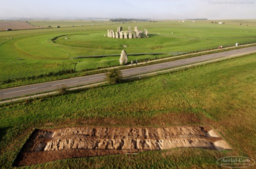
Archaeologists at the University of Buckingham, led by David Jacques found the ancient site in October 2014, which is around one-and-a-half miles (2.4km) from Stonehenge

The earliest datable “monumental” activity at Stonehenge comes from pine charcoal found at the bottom of two of the three enormous post pits that were discovered in the late 1960s when the old car park was being extended.

Radiocarbon-dated to around 7,500 – 7,900 BC these almost 1m diameter pine posts were erected back in the Mesolithic Age when the people inhabiting the British peninsular (not yet separated from Europe by water) were hunter gatherers.

The puzzle for archaeologists since has been to try and find where these people were living in the Stonehenge landscape.

The answer, it seems, is at Blick Mead.

In the last hundred years of research activity in the 26 sq. km. World Heritage Site only a tiny number of mesolithic flint tools have been found within a couple of miles of Stonehenge – fewer than 50 examples.

Jacques’ team of excavators have found, around the constant-temperature (11°C) chalk spring pool, more than 35,000 pieces of mesolithic worked flint, over 2,400 pieces of animal bone (some cooked), artifacts from very far afield and the possible remains of a mesolithic pit dwelling.

What’s more, it’s clear from the 16 radiocarbon dates so far obtained that these people were returning time and again to this resource rich sheltered spot, with its dependable non-freezing fresh water and abundant game, over at least 4000 years.

The dates range broadly from 7900BC to 4050BC, with multiple RC dates in each horsham-point-slate-tool
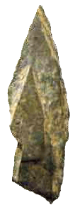
millennium from the 8th to the 5th BC, and they provide the first evidence of a possible continuity of societal activity across the mesolithic/neolithic boundary period.

One of the far-flung artifacts is a piece of slate that comes from Wales or the Welsh borders and which bears a striking resemblance to a kind of middle mesolithic tool called a Horsham Point – usually identified with the Sussex Weald.

Another is a unique (in Britain) sandstone tool made from material only found in the West Midlands.

Isotope analysis of a dog tooth from the dig suggests that its original owner grew up in the Yorkshire Wolds, implying that long-distance travel in the mesolithic was a commonplace – something that shouldn’t come as a surprise to us if we think about it.

spring-pool-and-ankle-bone

Over 50% of the animal remains are from aurochs (Bos Primigenius), a now extinct species of enormous cattle that once dominated the open grasslands of upland southern Britain. The ankle bone of one of these 2-tonne, 2m at the shoulder, beasts has the tip of a flint arrow or spear embedded in it. Presumably if you want to bring down a 40mph angry bull with thick skin and massive horns, you aim at its feet.

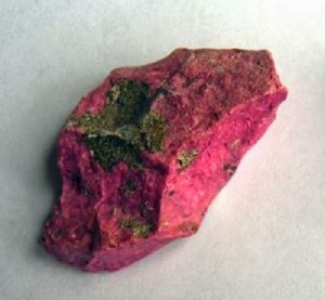
One of the oddest discoveries at the site was that flint removed from the spring pool and left to dry turned a vivid magenta pink colour. The transformation from brown stone to pink is magical to watch – who knows what it meant to the people who first encountered it.

The coloration is due to the existence of algae called Hildenbrandia Rivularis which grows on the cortex of flint nodules and requires very specific conditions of dappled sunlight, stable temperature water around 10-15°C and no competition.

pink-flintThe combination of conditions at Blick Mead have lead the researchers involved to suggest that the site acquired a special significance through long association in tradition with being a place of ancestral return. Perhaps this is part of the reason Stonehenge itself was eventually built close by.

The work at the site (which is on private land and therefore inaccessible to the public) continues each year and involves both professional archaeologists and dozens of volunteers from the local community in Amesbury and also further away.

The dig itself is being run by the University of Buckingham’s Humanities Research Institute: http://www.buckingham.ac.uk/humanities/ma/archaeology

An extensive display of some of the items found, along with explanations, can be visited at the Amesbury History Centre – a volunteer-run community project in Melor Hall on Church Street in Amesbury. See https://www.facebook.com/amesburyhistorycentre for opening times.

Stonehenge and Salisbury Guided Tours are considered the Stonehenge local experts should you wish to explore the Stonehenge Landscape and hear more about the Blick Mead excavations.  Stonehenge Guided Tours operate more general Stonehenge day tours from London but also arrange custom guided tours for those who want a more in-depth tour with an archaeological insight.

Article by guest blogger and local Stonehenge historian Simon Banton

Blick Mead News Links:
Is this the home of Stonehenge’s forefathers? 6,000-year-old settlement at Blick Mead ‘could rewrite British history’
The New Discoveries at Blick Mead: the Key to the Stonehenge 

The Stonehenge News Blog
Follow us on Twitter and Facebook for all the latest Stonehenge News


Why did the builders of Stonehenge choose Salisbury Plain?

23 10 2016

One of the most frequently asked questions about Stonehenge is “Why is it where it is?” and there are several possible explanations for this. They’re described below but it’s important to understand that combinations of these are also possible – there may not be just one single reason.

The location isn’t at all the obvious choice because it’s not at the top of the slope, which rises further towards the west. However, if you analyse the terrain you realise that it’s ideally positioned to give medium to long distance views to the northeast, southeast, southwest and northwest over a horizon that is relatively flat in profile.

In fact, the horizon is less than 1° in elevation in all directions.

Salisbury Plain

Archaeologists believe that there were only isolated stands of trees in the Salisbury Plain landscape at the time Stonehenge was built, far fewer than are evident today, so the far-reaching views that are hidden today by modern plantations wouldn’t have been obscured.

viewshed-and-horizon

In the Google Earth image the areas coloured red are directly visible from Stonehenge while the purple line shows the extent of the visible horizon (without trees in the way).

So why not build it further up the westerly slope and achieve even further-reaching views? To do so would be to lose some of the flatness of the horizon in key directions. As it is, Stonehenge appears to be in the centre of a bowl of visibility where the directions to the important astronomical events of summer and winter solstice sunrise and sunset are clear and level.

The second theory relates to the Station Stone Rectangle. Originally there were four Station Stones situated just inside the henge bank. Only two remain in place, the positions of the others (whose stoneholes have been detected) are known.

The short sides of this rectangle are parallel to the main alignment at Stonehenge – winter solstice sunset to summer solstice sunrise. In 1966, C.A. “Peter” Newham pointed out in an article in

station-stone-rectangle

Nature that the long sides of the rectangle are aligned on the extreme moonrise and moonset positions, in a cycle that takes 18.6 years to complete.

It’s a feature of the astronomical geometry that only at the latitude of Stonehenge (give or take 30 miles) that these solar and lunar alignments occur at right angles to each other. Further north or south than that limit and the Station Stone Rectangle would become a parallelogram.

The third possibility concerns the Heel Stone and the Avenue. The Heel Stone is an unshaped sarsen boulder weighing in at over 35 tons that is positioned to the northeast of Stonehenge at the top of the ceremonial approach way called the Avenue. It is traditionally associated with marking the position of sunrise on the summer solstice as seen from the centre of the circle.

During excavations by the Stonehenge Riverside Project in the mid-2000s, a series of features were discovered at the top of the Avenue which have been identified as “periglacial stripes”. These cracks and runnels in the underlying chalk where water has repeatedly frozen and thawed happen to run exactly along the main solstice alignment down the slope to the northeast beyond the Heel Stone.

periglacial

The SRP team suggest that these features would have been visible as parallel lines in the grass leading towards the Heel Stone. They go on to suggest that since the Heel Stone is unshaped, it may always have been lying in the landscape very close to where it has been set upright.

They conclude that a series of noticeable stripes in the grass leading up a slope towards a massive rock exactly in the direction of the winter solstice sunset may be the reason why this spot was regarded as a special place, worthy of memorialising.

Fourthly, there’s the theory that the combination of Bluestones from Wales with Sarsens from the more local area represents the symbolic political unification of two different groups of people at this spot on the borderland between their separate spheres of influence.

We do know that the area has been a focus of activity for more than 10,000 years going right back to the end of the last Ice Age in Britain, as shown by the recent discoveries at Blick Mead in Amesbury, and there are the massive Mesolithic post holes in the landscape only a couple of hundred metres northwest of Stonehenge.

Perhaps we’re looking at the continuation of a specialness that was handed down across the generations, with each successive group embellishing the stories and the monumentalisation a little for itself until finally we end up with a Visitor Centre that receives over a million people a year.

Ultimately though, the reasons for the choice of this location will remain one of the more puzzling Stonehenge mysteries.
Article by guest blogger and local Stonehenge historian Simon Banton

Salisbury Plain links:
Salisbury Plain Safaris offers a unique look at the dramatic landscapes, rich history and picturesque villages surrounding Salisbury, Stonehenge and the surrounding villages.
Stonehenge Guided Tours offer unique guided tours of the Stonehenge landscape and Salisbury Plain
Stonehenge ATV. This is what you have been looking for – the ultimate two seater buggy Salisbury Plain experience.
Visit Wiltshire.  Looking for more information on the famous Salisbury plain?…If so, click here to get the latest information direct from the official Wiltshire tourism site!

The Stonehenge News Blog
Follow us on Twitter and Facebook for all the latest Stonehenge news and discoveries


Bronze Age burial near Stonehenge discovered by badger

9 02 2016

A Bronze Age cremation burial has been discovered near Stonehenge after being accidentally dug up by a badger.

bronze-age-find

An archer’s wrist guard and shaft straighteners were among the objects discovered

Objects found in a burial mound at Netheravon, Wiltshire, include a bronze saw, an archer’s wrist guard, a copper chisel and cremated human remains.

Experts believe the burial may have been that of an archer or a person who made archery equipment.

The artefacts date back to 2,200-2,000BC, senior archaeologist Richard Osgood, of the MOD, said.

The burial mound, about five miles north of Stonehenge, lies on MOD land.

Mr Osgood, from the MOD’s Defence Infrastructure Organisation, said it was “an exciting find”.

“It was utterly unexpected. These are wonderful artefacts from the early Bronze Age, about 2,200-2,000 BC,” he said.

wilts-map

Other archaeological finds in Wiltshire:

1. Bronze Age burial discovered by a badger

2. Soldiers uncover 27 ancient bodies at Barrow Clump on Salisbury Plain

3. Researchers find large Neolithic site at Durrington Walls

4. Stonehenge dig finds 6,000-year-old encampment at Blick Mead

5. Bronze Age child’s skeleton discovered at Wilsford henge

6. Bronze Age jewellery discovered in a Wiltshire field

7. Iron Age woman’s footless body found near West Knoyle

8. Bronze Age hoard found near Tisbury


Also among the finds were shaft straighteners for straightening arrows, and pieces of pottery.

Mr Osgood said the badger had dug out the cremation urn and sherds of pottery were lying on the surface when they were spotted.

A full archaeological dig was then carried out on the site.

Mr Osgood said: “There are badger setts in quite a few scheduled monuments – the actions of burrowing animals is one of the biggest risks to archaeology in Britain – but to bring out items of this quality from one hole is unusual.

“We would never have known these objects were in there, so there’s a small part of me that is quite pleased the badger did this… but it probably would have been better that these things had stayed within the monument where they’d resided for 4,000 years.”

Injured military personnel and veterans helped to excavate the site.

The items are due to be put on display at Wiltshire Museum in Devizes later this year.

Read the full story (source) on the BBC website

The Stonehenge News Blog


Stonehenge discovery could rewrite British pre-history

20 12 2014

The most important discovery at Stonehenge for a generation could be destroyed by David Cameron’s plan to build a tunnel at the World Heritage Site

David Cameron announced plans to route the A303 into a tunnel to take traffic away from the world heritage site of Stonehenge Photo: AP

David Cameron announced plans to route the A303 into a tunnel to take traffic away from the world heritage site of Stonehenge Photo: AP

Archaeologists have discovered the earliest settlement at Stonehenge – but the Mesolithic camp could be destroyed if government plans for a new tunnel go ahead.

Charcoal dug up from the ‘Blick Mead’ encampment, a mile and a half from Stonehenge, dates from around 4,000BC. It is thought the site was originally occupied by hunter gatherers returning to Britain after the Ice Age, when the country was still connected to the continent.

Experts say the discovery could re-write history in prehistoric Britain.

There is also evidence of feasting – burnt flints and remains of giant bulls – aurochs – as well as flint tools.

The dig has also unearthed evidence of possible structures, but the site could be destroyed if plans for a 1.8 mile tunnel go ahead.

Earlier this month David Cameron, the prime minister, visited Stonehenge, in Amesbury, Wiltshire and announced plans to duel the A303 and build a new tunnel to take traffic away from the world heritage site.

But archaeologists want more time to assess the importance of the site and record new findings.

“The PM is interested in re-election in 140 days – we are interested in discovering how our ancestors lived six thousand years ago,” said archaeologist David Jacques, who made the discovery on a dig for the University of Buckingham.

“British pre-History may have to be rewritten. This is the latest dated Mesolithic encampment ever found in the UK.


A shard of bone found at the site

“Blick Mead site connects the early hunter gatherer groups returning to Britain after the Ice Age to the Stonehenge area all the way through to the Neolithic in the late 5th Millennium BC.

“Britain is beginning across this time period. Blick Mead connects a time when the country was still joined to the mainland to it becoming the British Isles for the first time.”

The experts believe that the site could show the Stonehenge was built as a monument to the ancestors of Neolithic Britons.

“Our only chance to find out about the earliest chapter of Britain’s history could be wrecked if the tunnel goes ahead,” added Mr Jacques.

A previous dig at the site, led by the University of Buckingham, revealed Amesbury is the longest continually-occupied place in the country. They discovered that frogs’ legs from 7,000 years ago were a delicacy here long before the French took a liking to them.

Archaeologists believe that early Britons were drawn to the site because of a natural spring. A The combination of a water of a constant temperature and a rare algae also produced the only colour-changing stones, which change from brown to pink, found at any archaeological site in the country.

Professor Tim Darvill, of Bournemouth University has described this as “This is the most important discovery at Stonehenge in over 60 years.”

Experts are calling on the government to rethink plans to build on the critically important landscape.

Andy Rhind-Tutt, of Amesbury and chairman of the Amesbury Museum and Heritage Trust, added: “Traffic congestion to one of the country’s most visited attractions will not be solved by a tunnel with one exit lane – the current tailback can extend five miles and can take two hours to get through.

“Any tunnel would need to be motorway standard, and even with four lanes there would still be tailbacks.

“A much more practical solution would be to reroute the A303 supporting South Wiltshire as well as the West Country.”
Article by , Telegraph Science Editor: http://www.telegraph.co.uk/news/earth/environment/archaeology/11303127/Stonehenge-discovery-could-rewrite-British-pre-history.html

Merlin @ Stonehenge
The Stonehenge News Blog


‘Old ones’ reference links 8th century poem to Stonehenge?

23 10 2014

AN ancient poem believed to have been written about Bath could in fact be the earliest writing ever discovered about Stonehenge, according to an academic expert following a presentation last night at the Amesbury History Centre. 

Dr Graeme Davis.jpg-pwrt2Mediaeval language scholar Dr Graeme Davis believes an 8th Century Anglo Saxon poem called “The Ruin” could be the oldest known surviving text in the world to describe the monument.

Although the original manuscript is damaged, Mr Davis has translated the poem and said he was surprised to find references to the standing stones as the “old ones”.

Mr Davis is part of a team studying a constant spring at Blick Mead in Amesbury.

He believes that the Stones and Blick Mead spring could be those referred to in the poem.

The spring caught Mr Davis’ attention during recent visits to Amesbury and led to discussions with the Amesbury Museum and Heritage Trust over the interesting history of the area.

A spokesman for the trust said: “Graeme’s interpretation of this poem intriguingly focuses the mind on Stonehenge especially with the reference to a hundred generations passed and the naming of the Stones as “the elders” or “old ones”.

“If the spring is indeed Blick Mead, it reinforces links and unlocks another clue to Amesbury’s significance in British History.

“It is interesting to note the book is recognised as one of the greatest works of the Benedictine revival, for which Amesbury played a major role.”

The full translation can be found on the Amesbury Museum, Heritage Trust Facebook page and the hard copy can be seen at the Amesbury History Centre.

Article source: http://www.salisburyjournal.co.uk/news/11546570.Is_eighth_century_poem_about_Stonehenge_/

The Stonehenge News Blog


The New Discoveries at Blick Mead: the Key to the Stonehenge Landscape

29 10 2013

An archaeological team from the University of Buckingham’s Humanities Research Institute has been uncovering very large amounts of Mesolithic material from a site immediately adjacent to Stonehenge.

Stonehenge 
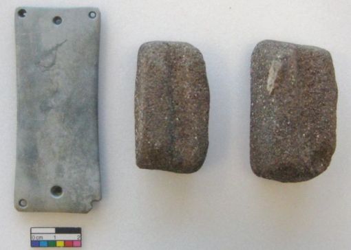
At a point called Blick Mead (a part of the Stonehenge landscape known as ‘Vespasian’s Camp’ on the mistaken assumption that it was the remains of a former Roman settlement) around 12,000 pieces of worked flint and burnt flint have been unearthed, as well as over 500 pieces of bone dating from over 8000 years ago. Virtually all the tools are in pristine condition – indeed, some of the team have had their fingers cut by them as they are still so sharp.

The most significant consequence of the excavation is that we have now discovered where the communities who built the first monuments at Stonehenge once lived – something that has eluded archaeologists for the best part of two centuries.  But the fact that the site also provides evidence for ritual activity in later periods suggests that the Buckingham team has also discovered a rare ‘multi-phase’ site, which was occupied over several millennia – indeed into the early medieval period.

David Jacques, Senior Research Fellow in Archaeology at the University of Buckingham’s Humanities Research Institute, has been directing the excavations at Vespasian’s Camp, Amesbury, Wiltshire, since 2005.

Burnt flint used in cookingThe archaeological potential of Vespasian’s Camp first came to light as a result of David Jacques’ detailed research of the site’s estate and nearby farm records. Indeed, before his team started their excavations, there was no evidence of Vespasian’s Camp having played any significant part in the Salisbury Plain ritual landscape or its history, and the site had been generally ignored by archaeologists, who assumed that any archaeological evidence on the site had been destroyed in the course of the landscaping of the area as a park for a neighbouring country house during the course of the 18th century.

Radiocarbon dating of objects from the Buckingham-sponsored excavations now shows that this site was occupied between 7550-4700 BC, which means that the Blick Mead site was in continuous use for almost 3,000 years.

This is generating great interest from archaeologists who have long pondered the possibility of a ‘missing link’ between the Mesolithic and Neolithic periods of activity at Stonehenge. The radiocarbon dates make this the oldest ever ‘homebase’ found in the Stonehenge area and could be one of the reasons why Stonehenge is sited where it is.

The findings produced by the Buckingham-funded excavations have led English Heritage to describe Vespasian’s Camp as potentially ‘one of the pivotal places in the history of the Stonehenge landscape’.

The 7500 BC dating of Blick Mead correlates strongly with the enigmatic posts found underneath Stonehenge car park in the late 1960s, which appear to be marking this area up as somewhere of special cultural significance

Finds from the springA copper alloy Bronze Age dagger, found nearby, at the Bluestonehenge monument in 2009, a 5th-century Anglo-Saxon disc brooch from a nearby spring, and medieval wooden staves from the main spring also connect Blick Mead to the early Anglo-Saxon and Amesbury Abbey periods. They add to the picture of the Blick Mead area being a place associated with veneration over the longue durée.

As a result of the support from the University of Buckingham’s Humanities Research Institute, further work is planned over the next two years.


Article Source: http://www.buckingham.ac.uk/research/hri/blickmead

Related link