Loop in the Landscape Workshop. Stonehenge Event 13th / 20th May.

3 05 2017

Take your imagination for a walk in this outdoor writing workshop in the Stonehenge Landscape. Working with award-winning poet Holly Corfield Carr, you will explore the ancient contours and hidden corners of the World Heritage Site, learning how to use field writing techniques and observational excercises to draw inspiration from even the smallest rock. (13th and 20th May at 2pm £5)

loop2

This event is generously supported by the National Trust and English Heritage and tickets include parking, refreshments, access to Stonehenge and a return journey to the Visitor Centre on a shuttle bus.

All ages and writing experience welcome. We are keen to meet local residents from Amesbury and Salisbury and the surrounding areas, as well as National Trust and English Heritage members.

Participants will have the chance to have their writing published as part of loop, a book of poems, photographs and walking routes celebrating life in the landscape around Stonehenge and Amesbury, the UK’s longest continuously-occupied settlement. For more information, please visit loop.org.uk.

looproutemap.jpg

Please be advised that the workshop will take place on the move and we will be walking at a gentle pace across 4km of uneven ground so please wear suitable footwear, clothing and sunscreen if appropriate. There will be regular breaks for writing and sitting on chairs which will be provided and the workshop will end with refreshments in the Neolithic Huts at the Visitor Centre.

More details: https://www.eventbrite.com/e/loop-in-the-landscape-tickets-33924131992

The Stonehenge News Blog
Follow us on Twitter and Facebook for all the latest Stonehenge New


Other Sarsen Stones near Stonehenge and Woodhenge

5 02 2017

Sarsen boulders lie scattered in substantial “drifts” across the landscape of the Marlborough Downs near Avebury.

By contrast, close to Stonehenge there are almost none. This is one of the reasons why most archaeologists believe that the large sarsens for the monument were not locally sourced.

There are, however, a few examples of substantial sarsens dotted about Salisbury Plain within a couple of miles of Stonehenge. And there are tantalising hints that others used to exist.

The most obvious, and easily accessible, is the Cuckoo Stone. This stone is about 2m long by 1.5m wide by 1.5m thick and lies in the field immediately west of Woodhenge.

Cuckoo Stone

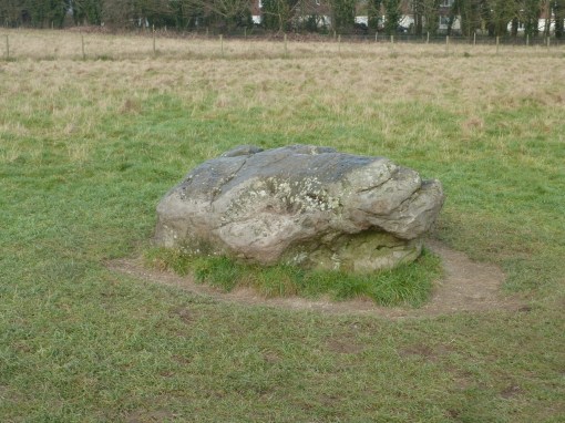
The Stonehenge Riverside Project excavated around the Cuckoo Stone in 2007 and discovered that the stone once had been set upright right next to the hollow in which it had originally formed.

Close by were two neolithic pits containing pottery worked flint, deer antlers and animal bones, dating to between 4000BC and 2000BC. A series of three burials were also found close by, dating to around 2000BC.

The stone remained a focus of activity right down to Romano-British times, and a small square wooden building – most likely a shrine – was built immediately to its southwest. Coins and pottery found in the ploughsoil date this to between 200AD and 400AD.

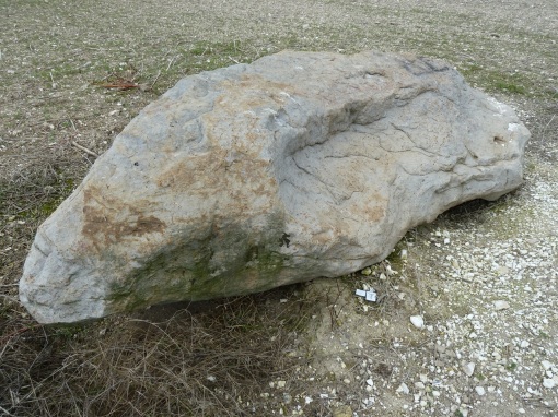
The other readily accessible sarsen is the Bulford Stone which lies in an arable field east of Bulford Village. It’s rather larger than the Cuckoo Stone at 2.8m long and again the excavation evidence shows that it too was once stood upright next to the hollow in which it formed.

It’s also closely associated with burials from the neolithic, the pottery found here dates to between 2300BC and 1900BC. The grave goods found were remarkable, including a flake of transparent rock crystal from either South Wales or the Alps and a “mini megalith” carved from a piece of limestone.

Bulford Stone.jpg

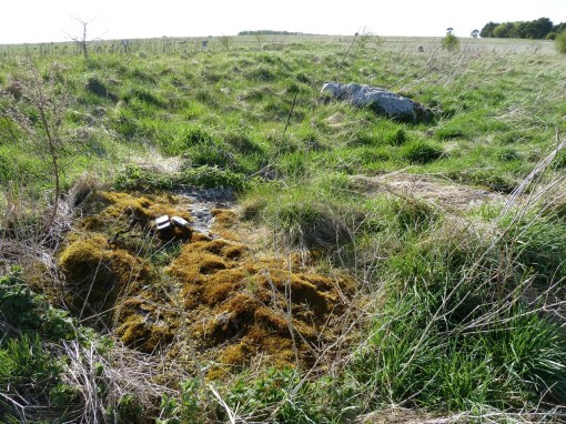
Lying in the northern ditch of a badly degraded long barrow within the Salisbury Plain military training area (and therefore not accessible to the public) are three more sarsen boulders.

They vary in size and – being half buried in the turf – are difficult to see, but the largest seems to be almost 2m long.

This long barrow was excavated by John Thurnam in 1864 who found an early neolithic burial on the original ground surface and an later Beaker burial just below the top of the mound.

Subsequent digging by the military in the early 20th century has almost obliterated the barrow but its outline can still be made out.

There is some debate about whether the sarsens lying in the ditch were originally part of the structure of the long barrow or if they were dragged there by farmers clearing fields at some later date. The stronger possibility is that they were part of the structure.

long-barrow-sarsens

John Britton in his “Beauties of Wiltshire (1801)” says:

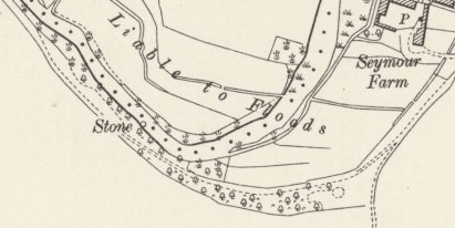
“About two miles north of Amesbury, on the banks of the Avon, is Bulford. Near this village are two large stones of the same kind as those at Stonehenge. One of them is situated in the middle of the river, and, as I am informed, has an iron ring fixed in it; but the waters being very high I could not see it.”

Old OS maps of the area show where this stone in the river once lay, but sadly it has now been removed and its present location is unknown to this author (please get in touch if you have any information about or pictures of it):
location-of-sarsen-in-river-os
“…
an interment which was lately discovered above Durrington Walls, by a shepherd, who in pitching the fold, found his iron bar impeded in the ground : curiosity led him to explore the cause, which proved to be a large sarsen stone, covering the interment of a skeleton”

There are other references to large local sarsens from antiquarian reports – one is mentioned by Sir Richard Colt Hoare in the early 1800s:

… and another by the Rev. Allan Hutchins from about the same time:

“In a field, not far from the road which leads from the Amesbury Turnpike into Bulford, is a Barrow of chalk facing the parish and standing by itself… When I came nearly to the virgin earth in this Barrow, my progress was impeded by an immense oval sand stone, underneath which was a skeleton, a beautiful lance head, and a handsome drinking cup”

Perhaps there are still more to be found. Certainly it seems that sarsen boulders of “large” or even “immense” size are not unknown in this part of Wiltshire so maybe the idea that the sarsens of Stonehenge were brought from the Marlborough Downs shouldn’t be accepted at face value.

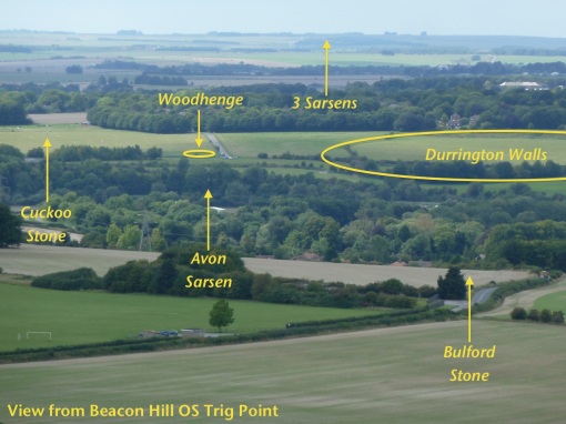
Here’s a view from Beacon Hill on the east side of Amesbury:

labelled-view-from-beacon-hill

… and here’s an overhead view from Google Earth:

locations-of-sarsens-around-stonehenge

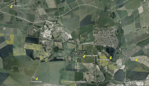
Curiously the Cuckoo Stone, the Avon Sarsen and the Bulford Stone all lie precisely on a straight line, with the Avon Stone being 1500 yards from the Cuckoo Stone and 1450 yards from the Bulford Stone.

But that’s another story……….

Want to learn more and here more Stonehenge stories? Hire a local expert tour guide or join a scheduled group tour
The Stonehenge Travel Company based in nearby Salisbury are considered the local experts and conduct guided tours of the Stonehenge landscape. Stonehenge Guided Tours include photo stops of Durrington Walls and Woodhenge and their private group tours service offer trips from London, Salisbury and Bath.  Stonehenge Walks offer archaeological guided walking tours

Article by guest blogger and local Stonehenge historian Simon Banton

The Stonehenge News Blog
Follow us on Twitter and Facebook for all the latest Stonehenge News
http://www.Stonehenge.News


Woodhenge Henge Timber Circle – Amesbury, Wiltshire. A wooden version of Stonehenge?

21 01 2017

“A little further on the right of the road leading to Amesbury, we see the mutilated remains of an enormous Druid barrow”

This is how Richard Colt Hoare described Woodhenge in the early 19th century, and it continued to be viewed as a disc barrow (with the name “Dough Cover”)  until 30th June 1926.

On that day, Squadron Leader Gilbert Insall VC took an aerial photograph that showed a series of dark circular cropmarks inside the area enclosed by what had been regarded as the barrow’s ditch.

Insall’s photo is shown below, Woodhenge is just above left of the centre.

gilbert-insall-woodhenge

These marks later proved to be the surface traces of six concentric rings of postholes, uncovered by Maud and Ben Cunnington in their excavations between 1926 and 1928. These posts date to between 2600 and 2400BC.

When their excavations were over, they installed short concrete markers to show the positions and sizes of the postholes, using colour-coded tops to indicate which holes belong to each concentric ring.

These are the markers that are still in place today.

The monument shares the same solstitial alignment as Stonehenge, pointing to summer sunrise in one direction and the winter sunset in the other. This photo shows winter solstice sunset.

As well as the postholes, the Cunningtons also discovered two burials and evidence that at least two stones had been erected on the site. Subsequent investigations in the mid-2000s found three more stone holes which show that large sarsens had been erected after the wooden posts had disappeared.

woodhenge-winter-solstice-sunset

One of the burials was near the centre – that of a small child about three years old whose skull was broken. At the time that was interpreted as evidence of sacrifice although it’s also possible that the weight of earth on the body was the actual cause of the damage.

The second burial was in a grave in the bottom of the surrounding henge ditch, dateable by the fragments of Beaker pottery found within. The ditch dates to between 2400 and 2100BC.

Other pottery discovered at the site is the distinctive earlier Grooved Ware style from the time of Stonehenge and some fragments of a much older style that indicates activity at the site dates back at least to between 3,800 and 4,000 BC.

Woodhenge is on a low ridge that overlooks the River Avon to its east, and is due south of the huge neolithic henge of Durrington Walls. Along this ridgeline to the south is evidence of a number of other barrows and also structures that made use of large timber posts.

It’s been suggested that these “four posters” might be the remains of excarnation platforms – elevated wooden areas where the bodies of the dead would be placed to be defleshed by the elements and carrion birds.

The fields around Woodhenge are rich in other archaeological remains. Apart from those already mentioned there is a ploughed-flat long barrow to the southwest. Recent geophysical research by the Stonehenge Hidden Landscapes Project has shown that beneath the ground surface there appears to be evidence of some kind of timber mortuary building.

woodhenge-longbarrow-geophys-comp

Access to Woodhenge is via a small slip road off the A345 north of Amesbury. There is a small, free, car park area and the monument itself is open at all times. The neighbouring fields immediately to the west (“Cuckoo Stone Field” and north (“Durrington Walls Field”) are owned by the National Trust and allow open access.

It’s well worth exploring this area to get a wider perspective of the landscape within the Stonehenge World Heritage Site. The Ordnance Survey Explorer series map #130 “Stonehenge and Salisbury” shows the public footpaths.
Article by guest blogger and local Stonehenge historian Simon Banton

Circular walking route from Woodhenge to Stonehenge
This walk explores two major historic monuments, Durrington Walls and Stonehenge, in the heart of the Stonehenge World Heritage Site. Visit the National Trust site for this trail.

Durrington Walls and Woodhenge, Wiltshire: Walk of the week
The first of our new series of weekly walks, provided by the National Trust, is a ramble around mysterious Durrington Walls in Wiltshire, with views towards Stonehenge. Visit the Times Travel webpage

How to see Woodhenge on a guided walk
The National Trust are hosting ‘Discover Durrington Walls and Woodhenge’ events throughout the year. On this 3-mile walk, you’ll explore the secrets of Durrington Walls – once home to the builders of Stonehenge – and discover 6,000 years of hidden history with National Trust’s landscape guides. Visit the National Trust events page.  Booking essential

Hire a local expert tour guide or join a scheduled group tour
The Stonehenge Travel Company based in nearby Salisbury are considered the local experts and offer archaeological guided walking tours of Woodhenge, Durrington Walls and the greater Stonehenge landscape. Stonehenge Guided Tours include photo stops and private group walking tours with transport from London

The Stonehenge News Blog
Follow us on Twitter and Facebook for all the latest Stonehenge News


Designers appointed for A303 tunnel at Stonehenge

15 01 2016

A DESIGN consultant has been appointed to develop a preferred option to improve the A303 between Amesbury and Berwick Down in Wiltshire.

303-henge-road

Traffic queues along the A303 past Stonehenge in Wiltshire as people head away to the west country this weekend. PRESS ASSOCIATION Photo. Picture date: Friday July 5, 2013. Photo credit should read: Chris Ison/PA Wire

As part of a £15B strategy to invest in roads over the next five years, the government has pledged to improve this section of the A303, including a tunnel near Stonehenge and a bypass of Winterbourne Stoke.

Highways England has announced that a package of work with an estimated value of £17.5M has been awarded to an Atkins/Arup joint venture. The companies will develop options to take to public consultation and ultimately will announce a preferred route.

Once the preferred route has been announced, the Planning Inspectorate will examine the development in public, before the transport secretary makes any final approval. Construction work is expected to begin by April 2020.

By WGD_Mumby

Read more: http://www.westerngazette.co.uk/Designers-appointed-A303-tunnel-Stonehenge/story-28528092-detail/story.html#ixzz3xIEN8jG0

The Stonehenge News Blog
Follow us on Twitter: https://twitter.com/ST0NEHENGE