Ordnance Survey Benchmarks at Stonehenge

18 11 2016

Amongst all the various carvings on the stones at Stonehenge, from the modern graffiti of the 17th to the 20th century and the ancient axe heads and daggers from about 1700BC, there are three that are not often noticed.

These are the Ordnance Survey (OS) benchmarks.

The OS website says: “Bench marks are the visible manifestation of Ordnance Datum Newlyn (ODN), which is the national height system for mainland Great Britain and forms the reference frame for heights above mean sea level.”

The original reference datum levelling survey was begun in Liverpool in 1840 using a benchmark on St. John’s Church, and in 1844 it was changed to the tidal pole in Victoria Dock. The reference Mean Sea Level (MSL) for the datum was established over a nine day period of tidal observations.

A second levelling survey was carried out in 1912-21 and the datum was changed to MSL at Newlyn in Cornwall. In the 1950s a third survey was performed, still making use of the Newlyn datum.

The OS benchmarks at Stonehenge are in the traditional form of three lines / | \ beneath a horizontal bar which is the indicator of the reference height above the datum’s MSL at that spot.

stone-16-annotatedCoincidentally, this is a similar form to that of the Druidic “Awen” emblem which also uses three lines / | \  but positioned below three dots rather than a horizontal bar. See https://en.wikipedia.org/wiki/Awen for the history and an explanation of this symbol.

At Stonehenge two of the benchmarks are on the Heel Stone and one is on Stone 16.

Stone 16 is the tooth-like stone at the southwest side of the monument directly behind the tallest stone on the site, and the benchmark is low down on the left of the southeast face.


This references the Newlyn datum, is 103.114m above MSL and was last verified in 1957.

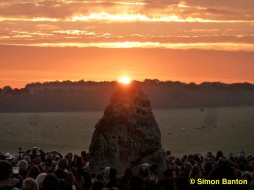
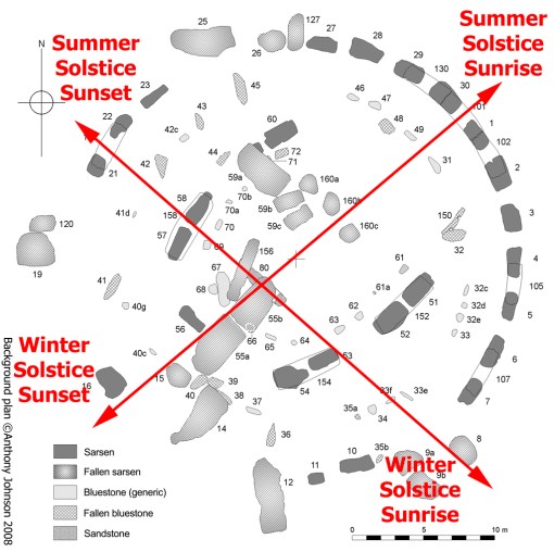
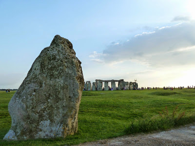
The Heel Stone is the massive leaning stone some 80m northeast of the stone circle which famously (but only roughly) indicates the position where the sun appears on the horizon at the summer solstice as seen from the centre of the stone circle.

Its benchmarks are low down on the right hand side of the northeast faceheelstone-annotated

The upper one references the original Liverpool datum, is 101.346m above MSL and was last verified in 1900.

The lower one references the Newlyn datum, is 100.7m above MSL and was last verified in 1957.

From the Newlyn benchmarks, you can work out that there’s a drop of 2.414m from the one on Stone 16 to the one on the Heel Stone.

None of these benchmarks are visible from any of the visitor paths around the monument, although if the light is right (early morning or evening in summer) the upper one on the Heel Stone can just be made out from the National Trust field.

To see them properly you’ll need to come to one of the Managed Open Accesses at the solstices or equinoxes.

Alternatively, you can book a private Stone Circle Access visit which take place most days of the year before and after regular opening times.

STONE CIRCLE ACCESS

Stone Circle Access visits, give you a unique opportunity to experience up close this world famous monument. The visits take place outside of our normal general admission opening hours and are subject to very limited availability. Please note that this is not a guided tour, and touching of the stones is not permitted.  You can try Stonehenge Guided Tours for these special access tours

Article by guest blogger and local Stonehenge historian Simon Banton

The Stonehenge News Blog
Follow us on Twitter and Facebook for all the latest Stonehenge news and discoveries


Solar Astronomy at Stonehenge

4 11 2016

Most people are aware that Stonehenge is somehow aligned to the annual movements of the Sun.

Each year thousands of pilgrims, druids and party-goers gather in celebration, hoping to Stonehenge Avenue.jpgwitness the most famous of these – the Summer Solstice Sunrise on June 21st.

At this time of year, as seen from the centre of the monument, the Sun rises in the same direction as the centre-line of the Avenue – the ancient processional approach to Stonehenge – towards the northeast.

The Stonehenge Avenue alignment was first pointed out by William Stukeley in 1740.

Even though almost everyone believes the Heel Stone was put up by the builders to exactly mark the summer solstice sunrise position, this can’t be true because it stands off to the right hand side of the alignment.

Today the Sun seems to rise out of the top of the Heel Stone due to the modern trees that are on the horizon.

heel-stone-sunrise

Walking up the Avenue they would have seen the Sun setting exactly into the middle of the stones between the uprights of the tallest trilithon in the southwest. We can still experience this today, even though only one upright of that trilithon – Stone 56, the tallest stone on the site – remains in place.

There’s a secondary alignment too – from Winter Solstice Sunrise to Summer Solstice Sunset.

This was first described by Prof. Gordon Freeman in 1997 and it makes use of a “notch” in the edge of Stone 58 of the western trilithon to give a clear sightline across the stone circle.

Viewed through this notch, Winter Solstice Sunrise is seen over Coneybury Hill to the southeast…

winter-solstice-sunrise

If they weren’t there, sunrise would be almost a Sun’s width to the left – and 4,500 years ago the Sun would have risen a whole degree further over to the left.

Even though the Heel Stone wasn’t intended as the solstice sunrise marker, the sight is still magnificent – when the weather cooperates.

Along the same alignment, but exactly in the opposite direction, lies the Winter Solstice Sunset point.

… and Summer Solstice Sunset is seen over Fargo Wood to the northwest.

What’s remarkable about these alignments through the circle is that they intersect over the centre of the Altar Stone (shown as Stone 80 in the plan below). The Altar Stone is not perpendicular to the main alignment but is offset so that it lies exactly along the secondary one.

image description

The intersection angle of 80° between summer and winter solstice sunrises at this latitude is echoed in the large gold lozenge discovered in 1808 when the Bronze Age “shamanic” burial from Bush Barrow, just south of Stonehenge, was excavated.

The intersection angle of 80° between summer and winter solstice sunrises at this latitude is echoed in the large gold lozenge discovered in 1808 when the Bronze Age “shamanic” burial from Bush Barrow, just south of Stonehenge, was excavated.bush-barrow-lozenge
Some see this as coincidence. Others believe the lozenge shows that the knowledge of this important astronomical angle was passed down the generations for at least 600 years.

The lozenge and the other astonishing Bush Barrow finds are on display at Wiltshire Museum in Devizes.

There are Stonehenge lunar alignments too, but that will be the subject of a different article.

Article by guest blogger and local Stonehenge historian Simon Banton

The Stonehenge News Blog
Follow us on Twitter and Facebook for all the latest Stonehenge news and discoveries


The Stones of Stonehenge. A new web site with a page devoted to each stone at Stonehenge.

11 02 2015

Strange as it may seem, there isn’t a useful reference work that shows photographs of every stone at Stonehenge from all (easily) available angles, until now.  The website is a work in progress toward that end. Not all stones currently have pages, but eventually they will have.

Stone Numbering System

The numbering system for the stones is that devised by W.M. Flinders Petrie in the late 19th century and which is still in use

Heel Stone

The HeelStone (or HeleStone or HealStone) is a natural stone that has not been worked or tooled.

by researchers and archaeologists to this day.

Petrie carried out one of the first highly (and dependably) accurate surveys of Stonehenge and decided that all previous systems of numbering the stones were inadequate in one way or another.
He resolved to number the stones in ascending order clockwise from the main axis of the monument and beginning with the sarsen immediately to the east of the axis in the outer circle as seen from the centre. This is Stone 1. All the actual and supposed positions of sarsen stones are numbered, whether or not there is a stone (or fragment of stone) at or near the position.
The horizontal lintels of the outer sarsen circle are numbered by adding 100 to the number for the higher of the two uprights that support each one. So the lintel supported by Stones 4 and 5 is numbered 105, and that supported by Stones 21 and 22 is numbered 122.
There is a single exception to this rule for the lintel spanning Stones 30 and 1 across the main entrance into the monument which is numbered 101 rather than 130. This is because the number 130 is already in use for the neighbouring lintel that is supported by Stones 29 and 30.
The bluestones of the circle within the sarsen circle are similarly numbered clockwise from the main axis beginning with Stone 31. In the case of the bluestones, Petrie did not assign numbers to the supposed positions of any that are missing.
The sarsens in the horseshoe of massive trilithons are numbered clockwise starting from Stone 51 round to Stone 60. Their respective five lintels (or “imposts” as Petrie called these huge lintels) are numbered 152, 154, 156, 158 and 160.
The bluestones of the innermost horseshoe arrangement are numbered clockwise from Stone 61.
The Altar Stone is Stone 80. The two remaining Station Stones outside the circle are numbered 91 (eastern stone) and 93 (western stone). Station Stones 92 and 94 are missing. The Slaughter Stone is Stone 95 and the Heel Stone is Stone 96.
Fragments of stones which are clearly associated with each other are given alphabetical indices, for example Stones 55a and 55b are the two parts of the broken fallen sarsen upright of the Great Trilithon.

Image credit:

Merlin @ Stonehenge
The Stonehenge News Blog