The Stonehenge Hidden Landscapes Project is an unprecedented initiative to survey a vast tract of land around the iconic stones. Now that the bulk of the practical work is complete, Carly Hilts spoke to Vince Gaffney and Chris Gaffney to find out more.

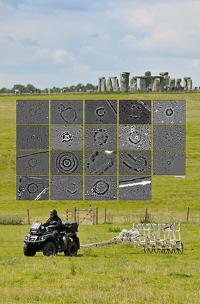
An ambitious programme of geophysical survey, covering 12 square kilometres around Stonehenge, has revealed a landscape scattered with previously-unknown features. Credit: All images courtesy of the University of Birmingham and LBI ArchPro
Stonehenge could confidently claim to be one of the most-studied, and certainly most hotly debated, prehistoric sites in Britain. However, much of the local landscape, so important to any interpretation or understanding of the site, was largely terra incognita – until the launch of The Stonehenge Hidden Landscapes Project, the largest geophysical mapping survey of its kind yet undertaken.
Begun in July 2010, and headed by the University of Birmingham and the Ludwig Boltzmann Institute for Archaeological Prospection and Virtual Archaeology in Vienna, the four-year Project has explored a massive 12 square kilometres around the celebrated stones, and revealed the footprints of hundreds of previously unknown features, invisible to the naked eye, including henge-like monuments, burial mounds, ditches, and pits spanning thousands of years.
Clocking up 120 days in the field, the team used the latest non-invasive survey techniques – including magnetometry, ground penetrating radar (GPR), earth resistance surveys, and 3D laser scanning – to explore the Stonehenge landscape in unprecedented detail, allowing researchers to see features buried as much as 3m below the modern ground level.
‘We created a palimpsest,’ said geophysics expert Dr Chris Gaffney of the University of Bradford. ‘Unpicking it is one of the joys of geophysics, but also one of its conundrums – we don’t have a ditch detector or a wall detector, so after gathering this incredible explosion of data, you still have to delve in and interpret it manually.’
So far, eagle-eyed project members have picked out 17 shapes from the vast amounts of resulting data that are thought to represent Neolithic monuments roughly contemporary with Stonehenge, as well as field enclosures, barrows, settlements, and other signs of human activity ranging in date from the Bronze Age to the 20th century.
We approach the features as we would if we were using aerial photography, by looking at their shape and comparing them to known sites,’ said project co-director Professor Vince Gaffney of the University of Birmingham (and brother of Chris Gaffney). ‘The tricky thing is that prehistoric monuments come in a variety of forms, they do not conform to standards – even Stonehenge is not a typical henge, as its ditch lies outside its bank – so once you spot something, it is not always easy to categorise it.’
Professor Wolfgang Neubauer, Director of the Ludwig Boltzmann Institute, added: ‘No landscape deserves to benefit from a study at this level of detail more than Stonehenge. The terabytes of digital survey data collected, processed and visualised by LBI ArchPro provide the base for the precise mapping of the monuments and archaeological features buried in the subsurface or still visible in the landscape surrounding Stonehenge. After centuries of research, the analysis of all mapped features makes it possible, for the first time, to reconstruct the development of Stonehenge and its landscape through time.’
High-speed survey
With an ambitiously large area designated for investigation, the team called on other modern technologies to help cover the uneven terrain. Although hand-pushed carts were used to explore more difficult or sensitive sites, much of the project survey equipment was mounted on the back of quad bikes.
‘This means we were collecting data at up to 40kmph,’ said Vince. ‘It was georeferenced and its location logged as it came in, and the information would already be partly processed before you reached the end of the field – that’s how we managed to so much data in a relatively short time.’
Beyond the stones of Stonehenge
This multi-technology approach has proven a particular boon in revisiting well-known sites, where a host of unexpected new details have been revealed. Around 3km from Stonehenge lies , the largest-known henge in the world at over 0.5km in diameter, and home to a Neolithic settlement that some interpret as a possible base camp for the builders of Stonehenge (CA 270). Although the site has been studied in detail during previous investigations, the recent survey identified traces of a previously unknown row of holes along the site’s southern border, which could have held around 70 posts or stones.

Another enigmatic find comes from the adjacent site of ‘Woodhenge’, once home to a Neolithic timber circle. The chalk long barrow standing in the same field had long been known to archaeologists, and so it came as a complete surprise to discover that the monument seems to have a kind of forecourt in front of it – and that within the mound itself there once stood a massive timber building some 33m long. With the outline of its walls marked out by lines of holes that once contained huge wooden posts, the team has provisionally interpreted the building as a mortuary, possibly used in excarnation rituals.
Interpreting the Cursus

Over at the Cursus – the c.3km long Neolithic earthwork just north of Stonehenge, thought to predate the earliest phase of the monument’s construction by several centuries –exploratory work has revealed new links between the two sites, as well as potentially significant astrological associations. At each end of the Cursus, the team has identified a massive pit measuring around 5m in diameter. More excitingly, Vince said, if you stand at Stonehenge and look towards the Cursus on the Summer Solstice, the easternmost pit aligns with the rising sun, and the westernmost with the sunset.
‘As the Cursus runs East-West it has long been suspected that it had some kind of association with the sun, so these pits forming a triangle with the site of Stonehenge are very interesting,’ he said. ‘It seems like a massive coincidence if their alignment was not intentional. We don’t know their date, but something else that is interesting to note is that while you can get a clear view of the sunrise pit from Stonehenge, looking down the first section of the Avenue, the sunset pit is hidden behind a bank. You might be able to see it if it was filled with fire and smoke, though – perhaps a future excavation will reveal traces of burning.’
This is an extract, but you can read the full article in Current Archaeology 296
Stonehenge’s hidden landscape
The Stonehenge News Blog