As the summer solstice will soon see thousands gather at Stonehenge, an archaeologist discusses his belief that the Wiltshire monument is evidence of a great civilisation which once thrived there

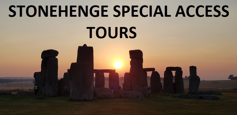
Sunrise at Stonehenge - June 21st
This primordial circle of stones, eight miles north of Salisbury in Wiltshire, exerts an extraordinary power over the people of Britain.
Some, like the Druids, claim it is the source of a mystical power while others, curious but sceptical, believe it to be the site of an ancient monument that has no relevance to the way we live today.
Whatever their conviction they are all missing the point according to one man who has studied the location for 30 years and believes he knows the real reason why Stonehenge is so special.
“Stonehenge is unique; it is already recognised as a World Heritage Site but it’s more than just an ancient curiosity, it is the place where civilisation began,” says writer and archaeologist Robert John Langdon.
“It’s simply the most amazing place in the world and we should all be celebrating the meaning of this incredible place.”
Robert fell under the spell of Stonehenge as a boy. He explored the massive stone monoliths and was intrigued by the official explanation of their origin. As the years passed and he learned more he was puzzled by contradictions in official explanation of its origins.
“The carbon dating of the stones is not consistent. I have discovered that stone post holes in what is now the car park for the site predate the accepted date for Stonehenge by 5,000 years. If this evidence is accepted, and it has been denied for years, it turns the conventional history of Stonehenge, and the rest of the world for that matter, on its head.”
“The geography and landscape of the site would have been very different. Britain would have been emerging from the last Ice Age, so much of the country we now recognise would have been under water. Stonehenge would have been on an estuary that led to the open sea. Too many important facts have been ignored,” says Robert.
“There is evidence that water was close, but that has been classified as a moat which I believe is wrong. It is also believed the stones were dragged over land from Wales which is misleading.
“The large sarsen stones came from an area close to Avebury which is not far from Stonehenge. To have brought them overland all the way from Wales takes no account of the fact that according to the official time scale Salisbury Plain at that time would have been heavily forested which would have made that access all but impossible. The bluestones, which are the key to the secret of Stonehenge, were smaller and did come from Wales but they were brought there by boat.”
Robert’s hypothesis is based on his conviction that the men who built Stonehenge were much more skilled and sophisticated than is currently believed. In 10,000 BC, the Mesolithic period, he believes that men in ancient Britain developed the first recognisable civilisation and that Stonehenge was their greatest achievement.
“These were extremely capable people who found a way of drilling into stone and used sophisticated mortice and tenon joints to erect Stonehenge but most importantly they mastered the seas. These boat people, as we can call them, travelled widely and traded and these are the people I believe that Plato referred to in his writings on the origins of civilisation.”
So why did these people make such an effort to build Stonehenge? what was it intended to do?
“Stonehenge was accessible to boat people from all over Europe and Mesolithic men and women came there to be cured of their ailments and to depart from this world. The alignment of the site to the sun and the moon is immensely significant but so is the presence of the bluestones in the circle.
“Bluestone turns blue in water, and was believed to have incredible powers of healing. Evidence from bones found close to Stonehenge suggests that the original inhabitants practised sophisticated medical procedures which included dentistry, limb removal and even brain surgery.
“These were not the fur-clad hunter gatherers living in mud huts that many mistakenly believe were the builders of Stonehenge. They were instead members of a great civilisation that moved out, leaving Stonehenge as the only surviving physical evidence of their genius.”
If Robert Langdon is right Stonehenge is much older than the Pyramids and there is a surprising connection between the two ancient stone monuments.
“Over the centuries the climate and landscape in Britain changed. Mesolithic men used their seafaring skills to move to a more sympathetic environment. They traded widely and sailed south to what is now the Mediterranean and moved in along the coast from Egypt to Greece and Italy. The ancient Egyptians’ skill at engineering and building with stone had its roots in the lessons learnt by the men who built Stonehenge.”
It is not only archaeologists with a theory about the significance of Stonehenge. The Druids regard it as a sacred place where they perform spiritual rituals.
Robert says: “I don’t have any disputes with the Druids and they don’t seem to mind me. I’ll be rubbing shoulders with lots of them at the midsummer solstice. The Druids may well have their beliefs but they came on the Stonehenge scene very late in the day.
“They would have discovered the site as an ancient and abandoned temple and taken it over but that’s all right. I get on pretty well with other archaeologists too although they do tend to dismiss my work, but that’s their loss. Stonehenge has a special hold on me and the more I learn about it the more fascinated I become. I’m already working on a new book which I think will ruffle quite a lot of feathers.
“In a sense what we know as Stonehenge is almost the foundations of a much bigger edifice. Stonehenge is, despite all the myths that have been fostered, a very special place. It is, I believe, the birthplace of civilisation and we all ought to give it the respect that it really deserves.”
Article from The Express Newspaper
Sponosred by ‘The Stonehenge Tour Compant’ www.StonehengeTours.com
Merlin @ Stonehenge
The Stonehenge Stone Circle Website