Building Stonehenge: A New Timeline Revealed

3 12 2012

Ancient people probably assembled the massive sandstone horseshoe at Stonehenge more than 4,600 years ago, while the smaller bluestones were imported from Wales later, a new study suggests.

ulian Richards in 2008, excavating a previously unsuspected cremation burial close to the edge of Aubrey Hole 7. Carbon dating suggests this burial was almost certainly made before the main ditch circuit was dug

ulian Richards in 2008, excavating a previously unsuspected cremation burial close to the edge of Aubrey Hole 7. Carbon dating suggests this burial was almost certainly made before the main ditch circuit was dug

The conclusion, detailed in the December issue of the journal Antiquity, challenges earlier timelines that proposed the smaller stones were raised first.

“The sequence proposed for the site is really the wrong way around,” said study co-author Timothy Darvill, an archaeologist at Bournemouth University in England. “The original idea that it starts small and gets bigger is wrong. It starts big and stays big. The new scheme puts the big stones at the center at the site as the first stage.”

The new timeline, which relies on statistical methods to tighten the dates when the stones were put into place, overturns the notion that ancient societies spent hundreds of years building each area of Stonehenge. Instead, a few generations likely built each of the major elements of the site, said Robert Ixer, a researcher who discovered the origin of the bluestones, but who was not involved in the study.
“It’s a very timely paper and a very important paper,” Ixer said. “A lot of us have got to go back and rethink when the stones arrived.”

Mysterious monument

The Wiltshire, England, site of Stonehenge is one of the world’s most enduring mysteries. No one knows why prehistoric people built the enigmatic megaliths, although researchers over the years have argued the site was originally a sun calendar, a symbol of unity, or a burial monument.

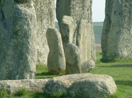
Though only some of the stones remain, at the center of the site once sat an oval of bluestones, or igneous rocks (those formed from magma) that turn a bluish hue when wet or freshly cut. Surrounding the bluestones are five giant sandstone megaliths called trilithons, or two vertical standing slabs capped by a horizontal stone, arranged in the shape of a horseshoe.

Around the horseshoe, ancient builders erected a circular ring of bluestones. The sandstone boulders, or sarsens, can weigh up to 40 tons (36,287 kilograms), while the much smaller bluestones weigh a mere 4 tons (3,628 kg).

Past researchers believed the bluestone oval and circle were erected earlier than the massive sandstone horseshoe.

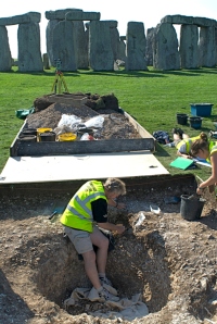
But when Darvill and his colleagues began excavations at the site in 2008, they found the previous chronology didn’t add up. The team estimated the age of new artifacts from the site, such as an antler-bone pick stuck within the stones. Combining the new information with dating from past excavations, the team created a new timeline for Stonehenge’s construction.

Like past researchers, the team believes that ancient people first used the site 5,000 years ago, when they dug a circular ditch and mound, or henge, about 361 feet (110 meters) in diameter.

But the new analysis suggests around 2600 B.C. the Neolithic people built the giant sandstone horseshoe, drawing the stone from nearby quarries. Only then did builders arrange the much smaller bluestones, which were probably imported from Wales. Those bluestones were then rearranged at various positions throughout the site over the next millennium, Darvill said.

“They sort out the local stuff first, and then they bring in the stones from Wales to add to the complexity of the structure,” Darvill told LiveScience.

The new dating allows the archaeologists to tie the structure to specific people who lived in the area at the time, Darvill said. The builders of the larger sandstone structures were pig farmers found only in the British Isles. In contrast, the bluestone builders would’ve been the Beaker people, sheep and cow herders who lived throughout Europe and are known for the distinctive, bell-shape pottery they left behind.

The new timeline “connects everything together, it gives us a good sequence of events outside, and it gives us a set of cultural associations with the different stages of construction,” Darvill said.

Tia Ghose, LiveScience Staff Writer
http://www.livescience.com/25157-stonehenge-megaliths-timeline-enigma.html
Date: 30 November 2012 Time: 01:23 PM ET

“Stonehenge remodelled”
Timothy Darvill, Peter Marshall, Mike Parker Pearson & Geoff Wainwright
ANTIQUITY 86 (2012): 1021–1040

What did Stonehenge look like? How did it begin?

The new Antiquity features an article by Tim Darvill, Pete Marshall, Mike Parker Pearson & Geoff Wainwright called “Stonehenge remodelled”. It’s designed to be the definitive summary of the current rethinking about the monument’s construction history. You can see an abstract here, though you need to subscribe to read the paper. There is a much fuller study published by English Heritage available online

Link: http://mikepitts.wordpress.com/2012/12/01/stonehenge-in-five-easy-stages-or-perhaps-six/

Blog sponsore by ‘Stonehenge Guided Tours’ www.StonehengeTours.com

Merlin at Stonehenge


Writer gives his view on how and why Stonehenge was built

30 11 2012

Former building engineer Simon Mallon, of Frome, enjoyed a 40-year career before turning his hand to writing.

His latest novel On the Edge of the Blue gives a fascinating explanation of how and why Stonehenge was built.

stonehenge-bluestonesMr Mallon said: “The sheer effort expended by the constructors of the first Stonehenge suggests Europe’s most iconic ancient structure was created for a magnificent purpose. But what purpose?

“Astrological, mathematical, medical, all laudable ideas based on nothing more than guesswork and hunches and so very wrong.

“Stonehenge is older than it looks, it was built to defeat the greatest threat mankind ever faced, the Ice Age and it succeeded.”

Mr Mallon believes that the henge stood on the side of a massive lake, and that the Preseli stone that was used to build it was brought across the frozen sea from the Pembrokeshire mountains to Bristol and then on across the lake.

Link source: http://www.thisissomerset.co.uk
Relative link: http://brian-mountainman.blogspot.co.uk/ (The Bluetone Enigma)

Merlin says “There are many varying theories that have and are proposed for “why Stonehenge was built” and we are all entitled to our views. No one will have the complete answer”

Sponsored by ‘Stonehenge Guided tours’ www.StonehengeTours.com

Merlin @ Stonhenge


Bluestone mystery is topic of Archaeology Day

17 11 2012

The origins of the Stonehenge bluestones will headline an Archaeology Day today (Saturday).

The day, organised by Pembrokeshire Coast National Park Authority, will be held at the Merlin Theatre, in Pembrokeshire College, and will include five talks and question and answer sessions.

Guest lecturer Professor Mike Parker-Pearson of University College London will lead a talk about his research into how bluestones from the Preseli Hills became construction material for Stonehenge 5,000 years ago.

In addition Louise Barker and Toby Driver, of the Royal Commission on the Ancient and Historical Monuments of Wales, will share their discoveries on Skomer Island, while Roger Thomas will delve into the 19th century fortification of Pembrokeshire.

Tickets are £12, and include a light lunch and morning and afternoon coffee.
Visit www.orielyparc.co.uk or call             01437 720392      . To hold a display call             01834 862105      .

Link: http://www.westerntelegraph.co.uk

Blog sponsored by ‘Stonehenge Guided Tours’ – www.StonehengeTours.com

Merlin @ Stonehenge


Stonehenge Cycle Challenge – 2013

3 10 2012

Join the Stonehenge Cycle Challenge and pedal into history. In September 2013 members of English Heritage will be able to take part in an exclusive sponsored cycle ride, which traces the route of the Stonehenge bluestones from Wales to Wiltshire.

Starting at the Preseli Hills in the Pembrokeshire National Park and ending inside the stone circle at Stonehenge with a celebratory glass of champagne, this really is a monumental ride of a lifetime.

When is it and who can get involved?

This three day event, which runs from 13-15 September 2013, is ideal for keen cyclists with a love of history.

The journey will cover:

  • Preseli Hills to Llandovery on day one (approx. 50 miles)
  • Llandovery to Chepstow via Brecon Beacons on day two (approx. 60 miles) and finally
  • Chepstow to Stonehenge on day three (approx 65 miles).

Cyclists will be able to take in some of the most beautiful Welsh and English countryside with plenty of water stops along the way, as well as much-deserved pub lunches.

Why cycle Stonehenge?

This sponsored ride, open to both individuals and teams, will raise much needed money to help fund improvements to the unique prehistoric landscape surrounding Stonehenge.

These improvements include:

  • A new environmentally sensitive visitor centre 1.5 miles away at Airman’s Corner
  • Removing the current car park and facilities at the Stones and returning these areas to grass
  • Closure of the A344 with the section from Stonehenge Bottom to Byway 12 reverting to grass, allowing Stonehenge to be reunited with its ancient processional way

Find out more about our ambitious plans to transform Stonehenge.

Please note: a registration fee will be charged to cover the cost of the safe running of this event.

How to get involved

If you would like to take part in the Stonehenge Cycle Challenge, you can register your interest by emailing: cycle.stonehenge@english-heritage.org.uk

Or why not support Stonehenge without breaking out into a sweat by donating online.

Blog sponsored by ‘Stonehenge Guided Tours’ – www.StonehengeTours.com

Merlin says “Im out of breath just thinking about it”

Stonehnege News Blog


Moving the Stonehenge Bluestones: At last a successful method is demonstrated!

3 10 2012

Without a single archaeologist in sight, a couple of boat builders and an inspired TV company show just how easy it can be to load a full-size bluestone onto a replica Bronze-Age boat. Robin Heath was there and took some photographs
Stonehenge Bluestone experimentOn the 15th August, near Poppit Sands, in Cardigan, West Wales, several skilled artisans showed how they would load a boat with a multi-ton bluestone. They did this with a force 7 on-shore gale battering the shore-line. In the time it took for the tide to come in, a flawless lowering took place of a large bluestone onto a prepared cradle within a near-replica of the boat found at Ferriby during the early 70s.
Moving the BluestonesThe Ferriby boat has been dated around 2000 BC, making it much too late for the period of bluestone moving (given at around 2700 – 2400 BC depending on which source one reads). But the boat is entirely believable as a design possible within the known technology of that period. Basically, if one can make Stonehenge, replete with mortice and tenon joints and tongue and grooving in stone, then one can make planks and joints in wood!. The remains of timber roundhouses reveal how timber was strung and stitched together.
On the 15th August, near Poppit Sands, in Cardigan, West Wales, several skilled artisans showed how they would load a boat with a multi-ton bluestone. They did this with a force 7 on-shore gale battering the shore-line. In the time it took for the tide to come in, a flawless lowering took place of a large bluestone onto a prepared cradle within a near-replica of the boat found at Ferriby during the early 70s.

Under the direction of a film crew working for the state-side Discovery Channel, not a single multicoloured pullover bearded archaeologist was harmed during this risky undertaking, primarily because none were employed. Instead, the company wisely sought out highly skilled local craftpeople, Nick, Dougie and Paul, time-served in the construction and repair of wooden boats including one (www.Keewaydin.com) weighing in at over 100 tons, and having much experience of building large wooden structures for maneuvering seemingly unfeasibly heavy weights. They delivered the goods with utter confidence and without fuss. The spectacle was a joy to behold.

The history of replicating aspects of how the bluestones were moved from sites in the Preseli mountains of West Wales is colourful, to say the least.  In 1923, Dr H H Thomas, a petrologist, wrote a seemingly innocent paper indicating that most of the Stonehenge bluestones had originated from just a very few outcrops around Carn Meini, near the village of Mynachlog ddu in North Pembrokeshire. Ever since a series of vitriolic and quite emotional arguments have periodically flared up to either applaud Dr Thomas on finally nailing this vital question for Stonehenge researchers, or to completely rubbish his experimental methodology because the stones “must have got there by the action of glaciation.”

The question is an important one, because if moved by the hand of man, it poses some humdinger other questions about the capabilities and intentions of the Stonehenge builders. These are uncomfortable to mainstream archaeologists, many of whom lie awake at night racked with anxiety whenever the present rather cosy model of Neolithic life is threatened by increased reality.

This ‘bluestone argument’ has recently been reactivated through the work of a team of geologists and archaeologists whose most well-known spokesperson, the amiable Professor Mike Parker-Pearson (Sheffield), oversaw the excavation of a buried and large megalith from a lowland outcrop on the northern side of the Preselis near Pont Saeson, near Brynberian, in 2011.Although not a classic spotted bluestone, this beast’s geology exactly matched that of the nearby outcrop and also matched the chemistry of several others of the “non-bluestone bluestones” at Stonehenge. The theory is put forward that, based on the evidence so far, no ice-age could have moved this stone or other ones from this site over the Preselis to Stonehenge. That the outcrop lies adjacent to a tributary of the Nevern river also supports the theory of transport by river, then the sea, as per the now traditional theory first promoted in the 1950s by Professor Richard Atkinson (Cardiff) and described within his still remarkably comprehensive book Stonehenge (Unwin, 1956). A later edition of his book has a Byronic illustration ( by Alan Sorrell) of a raft holding a doomed bluestone and crewed by savages being lashed by a Pembrokeshire so’westerly.

Now Atkinson really was old school archaeologist. Never far from a cigarette holder and always sporting a bow-tie, ‘Dickie’ Atkinson produced a classic 1950s TV re-inactment of bluestone moving using ‘multiple punts’ and other supposedly neolithic craft on a stretch of the Bristol Avon, using public schoolboys as stone-age stone movers. It was all rather Enid Blyton and Eton mess.

This may appear laughably naïve to us today, yet later attempts have been far more dangerous to life and limb than this first filmed effort. Perhaps it was the lashings of ginger beer that fortified the crews on the Atkinson boats, or perhaps it was just that folk had far more common sense than today, for since then, two attempts have sent bluestones tumbling to the bottom of Milford Haven, or Neyland, and at least four people have been hospitalized with crushing and fracturing injuries as a result of attempting to lift or move these heavy monoliths.

During the heady days of the new millennium, a lottery funded attempt to take a bluestone from Carn Menyn to Stonehenge became part of local folklore, and is a story that will be told to grandchildren by their grandparents for a while yet, as it contains all the tragedy, farce and comedy of a good narrative. The fated single stone now languishes in 70 feet of water opposite Pembroke Dock, where it lends support to the dangerous theory that suggests, perhaps, we have actually devolved in our abilities as a species since the Stone Age.

Those who have taken the trouble to read my own contributions to the matter of Stonehenge (in books, presentations and via http://www.skyandlandscape.com) will appreciate that another question needs to be asked concerning the monument. Once they are seen to have been moved to Salisbury Plain by the hand of man, it goes beyond how the bluestones arrived there and becomes why they were so important in the monument? It is 135 miles (as the crow flies) from Preseli to Stonehenge, and these stones were not moved without some powerful driving motivation. What might that be, eh? If the glaciation theory is attenuated by this new evidence, then ipso facto the argument for the bluestones having been moved by human intent is fortified. And this then begs a really tricky ‘geomantic’ question: Might the location of the bluestones, rather than their geological composition, be a significant reason for their required presence at Stonehenge?

No one in academia presently wants to get anywhere near this question, yet today’s successful positing of a fat bluestone into the bowels of a believable neolithic boat scores an important point in supporting the theory that the moving of the bluestones occurred through human intent. That being the case, why the Neolithic culture should have been compelled to undertake such a task now surely commands our utmost attention.

Watch the increasing thrumming emanating from various blogs and websites manned 24/7 by researchers, zealots, seekers, bigots and unemployed folk sporting archaeology degrees. Finally, watch the documentary on the Discovery Channel when it comes out!

Written by
Source Link: http://www.matrixofcreation.co.uk/megalithic-sciences/item/93-moving-the-bluestones-at-last-a-successful-method-is-demonstrated

Blog sponsored by ‘Stonehenge Guided Tours’ www.StonehengeTours.com

Merlin says “The BIG  debate continues – Glacier V Bronze Age Boat”

 The Stonehenge News Blog


Prehistoric Wiltshire. Sites of Significance

1 05 2012

If you are in doubt about the key role Wiltshire plays in the long history of these Islands, and that it has done so since the time humans first set foot on our soil, this book joins the growing scholarly titles from the excellent ‘heritage; publisher Amberley Publishing will dispel it.

Prehistoric Wilsthire

Prehistoric Wilsthire

This attractive book is the latest in a successful series from the Stroud-based publisher Amberley. (Amongst others, their titles include Prehistoric Gloucestershire by Tim Darvill, and John Aubrey and Stone Circles: Britain’s First Archaeologist by Aubrey Burl.) It is well written by a knowledgeable local archaeologist in a style that is pleasingly free of jargon, and opens with a fitting tribute from Francis Pryor.

As with some other titles in the series, this pocket-sized book is specifically designed as a field guide (at 235 x 165mm it is slightly larger than A5), in this instance describing nearly 50 of the most visible and accessible prehistoric monuments within the county of Wiltshire. The selected sites are grouped by topographic region (the Marlborough Downs, the Vale of Pewsey and so on), the majority situated on the chalk uplands. All the familiar forms of earthwork from causewayed camps and long barrows to round barrow groups and hillforts are covered. Appropriately, they include the monuments of the World Heritage Site centred on Avebury and Stonehenge, but information from the latest fieldwork in those areas ensures up-to-date coverage.

An introductory section provides a brief outline of the conventional sub-divisions of later prehistory (the Mesolithic to the Iron Age). Thereafter, details are offered on how best to reach each site: although there are no maps, National Grid References and useful directions are offered. Some of the sites are on private land and hence the book judiciously warns ‘this guide does not infer rights of way’, deferring to the county’s highway authority for the latest information on footpaths and bridleways. Nonetheless, it describes what can be seen at each site from the best publicly-accessible vantage points. The entries briefly describe the history of investigation at each site and summarize current understanding of its function and date.

The book is beautifully illustrated. The majority of the figures are the author’s own fine colour photographs, although some monochrome archival images are also used where necessary. Arguably the best views are the excellent oblique aerial photographs. Their use as an invaluable aid to comprehension recalls the local tradition pioneered by O. G. S. Crawford and Alexander Keiller in their 1928 work, Wessex from the Air. Evidently, the author enlisted the help of several pilots, employing a range of micro-light and private aircraft to gain the necessary perspective. Because the book focuses on visible sites, most of the subjects are obviously upstanding earthworks. Nonetheless, the photographs include a few soil-marks, crop-marks and excavations to emphasis that even in an area which boasts some of the country’s best-known monuments, many others have been lost from normal view.

It is well known that Wiltshire contains a remarkable number of well-preserved field monuments of various forms, and hence the author is in the enviable position of being able to select the most impressive. Because of the quality and visibility of its ancient monuments, Wiltshire is an ideal region to serve as an introduction for those unfamiliar with prehistoric remains, but equally it is an unceasing source of inspiration for the most experienced archaeologist. The field monuments are complemented by outstanding local museums whose displays reflect the long history of archaeological investigation within the county. Yet, despite the richness of their collections, these museums remain the responsibility of private trusts and societies that constantly struggle to find the necessary resources to conserve and exhibit their assets. It is most commendable, therefore, that Bob Clarke, the author, has written Prehistoric Wiltshire as a personal contribution to the Wiltshire Archaeological and Natural History Society’s fund raising effort to re-display the famous Bronze Age gallery at Devizes Museum. There are thus two compelling reasons to buy this excellent book – to guide you to some of the best prehistoric sites in Southern England, and to help display the spectacular objects found in some of those sites.

Sponsored by The Stonehenge Tour Companyhttps://stonehengetours.com/

Merlin says “Visiting Wiltshire ? Buy this book!”

Merlin @ Stonehenge
The Stonehenge Stone Circle Website


STONEHENGE: UNCOVERED – February 24th 2012

22 02 2012

Unlock the secrets of Stonehenge and the surrounding sites in this exclusive walking tour led by English Heritages’ Properties Historian Susan Greaney.Visit the World Heritage Site and key archaeological areas in this fascinating landscape. Along the way, gain an exclusive insight into the new and exciting discoveries made by recent research projects carried out in the area and discover for yourself more about this special landscape.
Stonehenge HOW TO BOOK

Purchase your tickets today by calling our dedicated Ticket Sales Team on            0870 333 1183       (Mon – Fri 8.30am – 5.30 Sat 9am – 5pm). Please note: Booking tickets for this event is essential as places are limited

Link: http://www.english-heritage.org.uk/daysout/events/stonehenge-uncovered-s-24-feb/

Sponsored by ‘The Stoneheng Tour Company’ http://www.StonehengeTours.com

Merlin say “You have to be an English Heritage member for this tour but its well worth joining”

Merlin @ Stonehenge 


Scientists locate exact source of Stonehenge stone but how did they get there?

19 12 2011

Scientists have located the exact source of the rock believed to have been used to create some of Stonehenge’s first stone circle.

Researchers have been able to match fragments of stone from around the 5,000 year old monument with an outcrop of rock in south-west Wales.

Stonehenge Bluestone

Photo: ALAMY

The work – carried out by geologists Robert Ixer of the University of Leicester and Richard Bevins of the National Museum of Wales – has identified the source as a site called Craig Rhos-y-Felin, near Pont Saeson in north Pembrokeshire.

It is the first time that an exact source has been found for any of the stones thought to have been used to build Stonehenge.

The discovery has re-invigorated a long running debate as to whether the smaller standing stones of Stonehenge were quarried and brought from Pembrokeshire by prehistoric humans or whether they were carried all or part of the way to Wiltshire by glaciers hundreds of thousands of years earlier.

Archaeologists tend to subscribe to the ‘human transport’ theory, while geomorphologists often favour the glacial one.

The debate is solely about Stonehenge’s smaller standing stones which are sometimes known collectively as bluestones. The larger stones, or sarsens, are accepted to have been incorporated into the monument several centuries later.

The remarkable find has been reported in the journal Archaeology in Wales and opens up the possibility of finding archaeological evidence of quarrying activity at Craig Rhos-y-Felin which would indicate humans rather than glaciers were responsible for transporting the stone.

Research over recent years by Tim Darvill of Bournemouth University and Geoffrey Wainwright, a former chief archaeologist at English Heritage, suggests that the Pembrokeshire stones may have had a particular ideological significance.

The outcrops where some of the stones come from are thought to have been associated with sacred springs and local Welsh stone circles.

By bringing those particular rocks the 160 miles from Pembrokeshire to Wiltshire, the builders of Stonehenge may have thought they were obtaining more than just plain rock.

Experts have suggested they may have regarded the stone as having supernatural powers.

By DailTelegraph Reporter – http://www.telegraph.co.uk/earth/environment/8964899/Scientists-locate-exact-source-of-Stonehenge-stone.html

Sponsored by ‘The Stonehenge Tour Company’ – www.StonehengeTours.com

Merlin says: “Surely experts can establish if they were moved by glaciers or man power?”

Merlin @ Stonehenge
The Stonehenge Stone Circle Website


Hidden dimension of Stonehenge revealed

8 12 2011

A project directed by academics at the University of Sheffield has made the archaeology of the world-famous Stonehenge site more accessible than ever before.

StonehengeGoogle Under-the-Earth: Seeing Beneath Stonehenge is the first application of its kind to transport users around a virtual prehistoric landscape, exploring the magnificent and internationally important monument, Stonehenge.

The application used data gathered from the University of Sheffield´s Stonehenge Riverside Project in conjunction with colleagues from the universities of Manchester, Bristol, Southampton and London. The application was developed by Bournemouth University archaeologists, adding layers of archaeological information to Google Earth to create Google Under-the-Earth.

The unique visual experience lets users interact with the past like never before. Highlights include taking a visit to the Neolithic village of Durrington Walls and a trip inside a prehistoric house. Users also have the opportunity to see reconstructions of Bluestonehenge at the end of the Stonehenge Avenue and the great timber monument called the Southern Circle, as they would have looked more than 4,000 years ago.

The project is funded through Google Research Awards, a program which fosters relationships between Google and the academic world as part of Google’s ambition to organise the world’s information and make it universally accessible and useful.

Professor Mike Parker-Pearson from the University of Sheffield’s Department of Archaeology said: “Google Under Earth: Seeing Beneath Stonehenge is part of a much wider project led by myself and colleagues at other universities – the Stonehenge Riverside Project – which began in 2003. This new Google application is exciting because it will allow people around the world to explore some of the fascinating discoveries we’ve made in and around Stonehenge over the past few years.”

Archaeological scientist Dr Kate Welham, project leader at Bournemouth University, explained that the project could also be the start of something much bigger:

“It is envisaged that Google Under-the-Earth: Seeing Beneath Stonehenge could be the start of a new layer in Google Earth. Many of the world’s great archaeological sites could be added, incorporating details of centuries’ worth of excavations as well as technical data from geophysical and remote sensing surveys in the last 20 years.” she said.

Dr Nick Snashall, National Trust Archaeologist at Stonehenge said: “The National Trust cares for over 2,000 acres of the Stonehenge Landscape. Seeing Beneath Stonehenge offers exciting and innovative ways for people to explore that landscape. It will allow people across the globe, many of whom may never otherwise have the chance to visit the sites, to share in the thrill of the discoveries made by the Stonehenge Riverside team and to appreciate the remarkable achievements of the people who built and used the monuments.”

You can download the application from the Google Under-the-Earth: Seeing Beneath Stonehenge site. The tool is easy to use and requires Google Earth to be installed on your computer.

Notes for Editors:
Google Under-the-Earth: Seeing Beneath Stonehenge was created at Bournemouth University by Dr Kate Welham, Mark Dover, Harry Manley and Lawrence Shaw. It is jointly directed by Dr Kate Welham and Professor Mike Parker Pearson at the University of Sheffield.

To find out more about the University of Sheffield’s Department of Archaeology, visit: Department of Archaeology

The Stonehenge Riverside Project was a joint collaboration between Universities of Bournemouth, Bristol, Manchester, Sheffield and University College London. It was led by Professor Mike Parker Pearson, University of Sheffield, and co-directed by Professor Julian Thomas, University of Manchester, Dr Joshua Pollard, University of Southampton (formally University of Bristol), Dr Colin Richards, University of Manchester, Dr Chris Tilley, University College London and Dr Kate Welham, Bournemouth University.

This project has been supported by: The Arts and Humanities Research Council, the British Academy, the Royal Archaeological Institute, the Society of Antiquaries, the Prehistoric Society, the McDonald Institute, Robert Kiln Charitable Trust, Andante Travel, University of Sheffield Enterprise Scheme, the British Academy, the National Geographic Society, with financial support from English Heritage and the National Trust for outreach. The project was awarded the Bob Smith Prize in 2004 and the Current Archaeology Research Project of the Year award for Bluestonehenge in 2010.
Links: www.shef.ac.uk/

Sponsored by ‘The Stonehenge Tour Company’ www.StonehengeTours.com

Merln says: The tool is easy to use and requires Google Earth to be installed on your computer.

Melin @ Stonehenge Stone Cirle
The Stonehenge Stone Circle Website


3D Stonehenge Model Unveiled

16 09 2011

3d-stonehenge-scanEnglish Heritage have announced that the survey and initial data processing of the recent laser scan of Stonehenge is now complete, and present an update with a short video fly-though of the data.
A detailed survey of every stone that makes up Stonehenge using the latest technology, including a new scanner on loan from Z+F UK that has never before been used on a heritage project in this country, has resulted in the most accurate digital model ever produced of the world famous monument.

 With resolution level as high as 0.5mm in many areas, every nook and cranny of the stones’ surfaces is revealed with utmost clarity, including the lichens, Bronze Age carvings, erosion patterns and Victorian graffiti.

Most surprisingly, initial assessment of the survey has suggested that the ‘grooves’ resulting from stone dressing on some sarsen stones (the standing stones) appear to be divided into sections, perhaps with different teams of Neolithic builders working on separate areas.

A first glimpse of the model can now be viewed here
http://www.english-heritage.org.uk/about/news/3d-stonehenge-model-unveiled/

The model will be a powerful tool for tracking changes in the physical condition of Stonehenge, and for deepening our understanding of its construction and the thinking and working habits of its creators, plus changes to the monument in later history.

In March 2011 English Heritage commissioned 3D laser scanning specialists the Greenhatch Group, together with Atkins Mapping and Archaeo-Environment Ltd, to capture the stones and the landscape surrounding them at a level of precision and definition never before attempted. The survey includes all the visible faces of the standing and fallen stones of Stonehenge, including Station, Heel and Slaughter stones, as well as the top of the horizontal lintels.

 The resultant high resolution archival data and 3D meshed models is currently being synthesised and will be officially published and shared with the wider archaeological community in due course. Experts will also further analyse and study the archaeological significance of the data.

A variety of 3D models and datasets which can be manipulated and customised to simulate fly-over views of the monument from different perspectives will be used by  English Heritage’s interpretation team who is working on the new galleries of the proposed visitor centre.

http://www.stonehengelaserscan.org/

Sponsored by ‘The Stonehenge Tour Company’ – www.StonehengeTours.com

Merlin @ Stonehenge
The Stonehenge Stone Circle Website